
A snowy, serpentine giant
New Hampshire's most iconic highway never sleeps

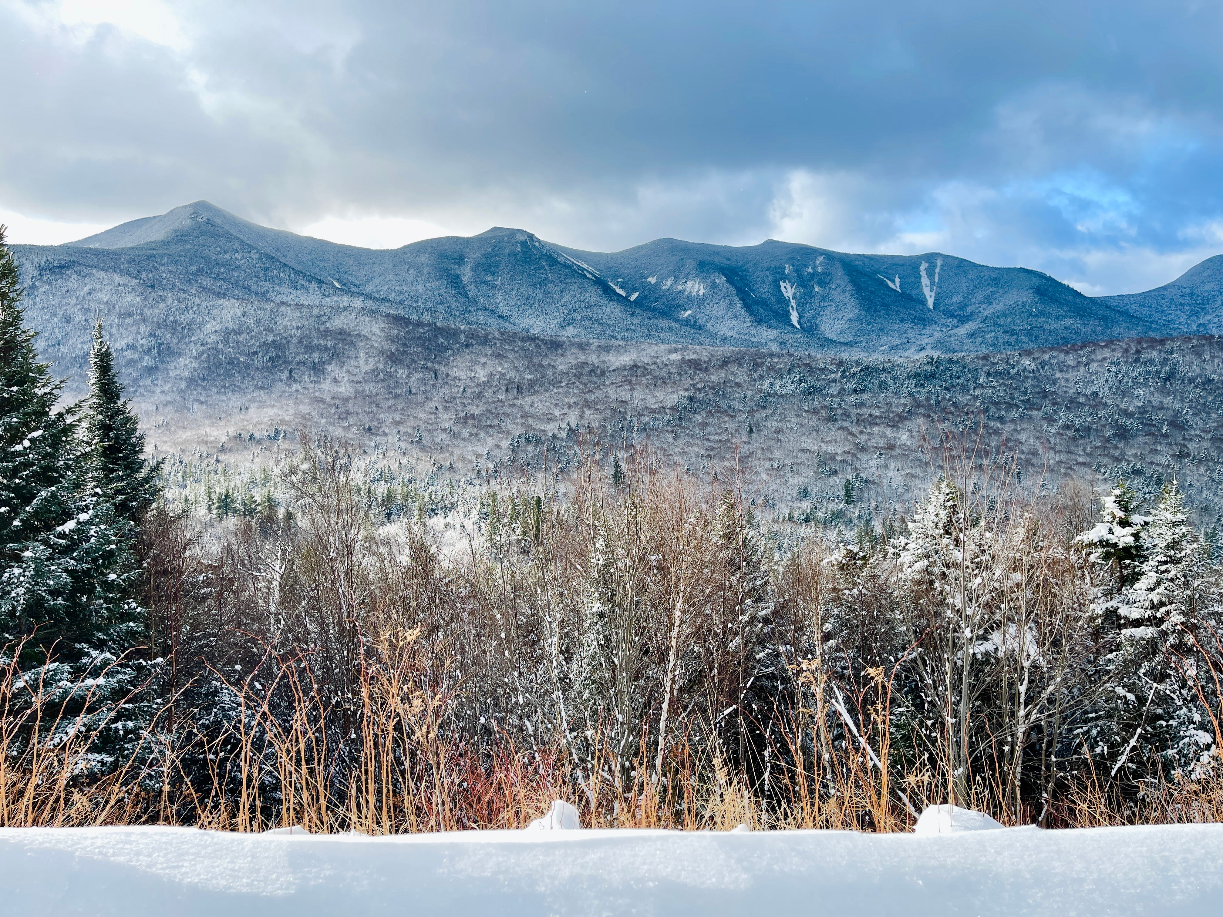
Winter in New England is one of the all-time great seasons for what I sometimes call Contrarian Travel—going against tourist wisdom and visiting a place at a time when most people wouldn’t think (or want) to be there. If you’ve ever witnessed a blizzard from the desolate beaches of Cape Cod in December, or shuffled your way across icy streets in Providence to some club where a hardcore punk show is imbuing the night with unlikely warmth, then you know what I’m talking about. The hulking mountains of New Hampshire and Vermont aren’t quite as forsaken during the snowiest months, given the regional popularity of skiing and winter hiking. But on the south end of the White Mountain National Forest, there’s one particular recreational feature that does feel strangely forgotten once the last wisps of the fall foliage have been blown away.
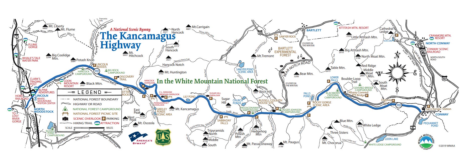
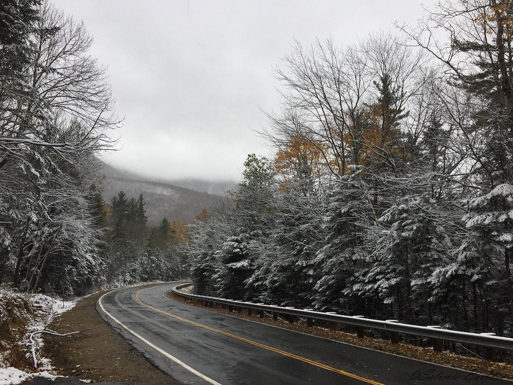
That feature is the Kancamagus Highway; the Granite State’s storied scenic byway that snakes and squiggles just over 34 miles from Lincoln to Conway, passing through the nexus of the Pemigewasset Wilderness and the Sandwich Range. This is a patch of the White Mountains that doesn’t incur the same level of feverish visitation as Franconia Notch or the Presidentials. But every September and October, the world suddenly remembers that this gorgeous mountain-climbing—and descending!—highway exists. And during those two months, “The Kanc” regresses into a ribbony parking lot, with thousands of cars competing for autumnal vistas from roadside overlooks, and top notch foliage immersion in places where the road weaves through deciduous forest.
Now, given the steep dropoff in Kancamagus action once the leaves have gone, you might assume that the highway is closed during winter; when a single snowstorm can easily blanket a scenic byway with 3 feet of powder. But The Kanc doesn’t close. Plows and road salt are deployed to keep the road passable and safe. This is remarkable for a coupe of reasons. It costs New Hampshire a lot of money to clear a highway like The Kanc, and yet, there’s no superlative recreation destination alongside the Kancamagus Highway that might easily explain such an investment. The closest downhill ski resort, Loon Mountain, is located at the western end of the highway in Lincoln. What you do find along The Kanc are quieter natural wonders. Hiking trails to curiously overlooked mountains. Waterfalls and ponds that stir in solitude. And the rocky bends of the Swift River—a roaring behemoth that’s upstaged by the neighboring Saco River. It speaks to the Granite State’s confidence and pride in the White Mountains that this byway is accessible to the public at a time of the year when most folks are hunkering indoors.
And this winter is your chance to visit The Kanc and see where that pride comes from.
When spending a shivery day on the Kancamagus Highway, I generally like to start at the west end in Lincoln. There’s something uniquely satisfying about launching from a place that’s teeming with ski resort traffic and transitioning into a calmer and ethereal realm; where you can really appreciate the luster of ice on evergreen boughs, and the occasional flare of color that breaks through the overcast sky, while you’re enjoying a mountain view from one of the highway overlooks. If there was ever a time and place for having a couple of Cocteau Twins albums in your car, it’s midwinter on The Kanc. The Scottish dream pop band’s magical melodies fit in perfectly here. But regardless of where you end up starting a Kancamagus drive, you’re in for a shitload of serenity.
What happens next, once you’re gliding along the undulations and occasional hairpin turns of The Kanc, really depends on your mood and your appetite for being outside amidst freezing temperatures and abundant snow or ice. If you sprang out of bed that morning, stared at yourself in the mirror as you brushed your teeth, and said, “I must climb something big on this day” (I imagine this is how most mountain climbing trips begin) the Kancamagus offers a nice range of doorways to summits. You could spend a few hours slogging uphill through boreal forest zones to Mount Hancock or the two Mount Osceolas, if you’re thinking of conscripting yourself into the 4,000 Footers club. And if you’ve logged some miles on winter peaks, you could challenge yourself with a Mount Chocorua ascent. The remarkably steep, pointy peak of this visually distinctive, 3,490-foot mountain often necessitates crampons—not microspikes—when it’s solidly iced up. Then there’s Hedgehog Mountain, a less severe destination that used to be the home of a University of New Hampshire forestry camp, for which the trail to the summit is still named. It’s a shorter, less quad-tenderizing hike, but it will still get you huffing and puffing—and sweating beneath all those insulating layers of winter wear.
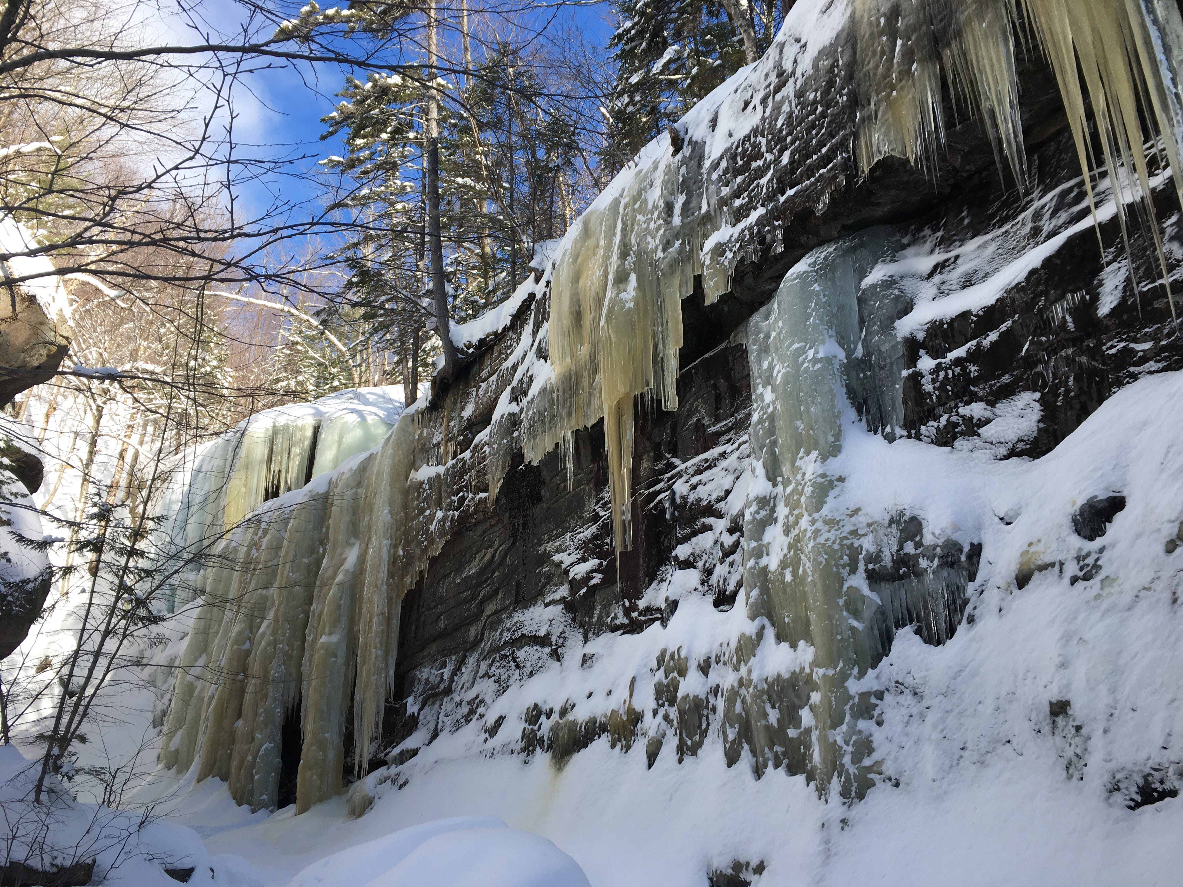
Occasionally, I’ve found the inspiration to rally and set off for one of the summits off of The Kanc. But each time I’ve turned into the parking area for the Champney Brook Trail (the beginning of the route to Mount Chocorua) my actual destination has been well below the treeline. 1.5 miles of moderately graded climbing along this trail is all that it takes to reach the base of Champney Falls, which spills elegantly down a series of cliff faces during the summer, only to be frozen solid into a curtain of ice in winter. Better yet, directly across from Champney Falls is a deep gorge where an even taller cascade is hidden. Pitcher Falls, a 50-foot plunge cascade, is one of the finest White Mountain waterfall deep cuts. Odds are you’ll have it all to yourself on a winter visit.
The same goes for a more broadly recognized cascade near the midpoint of The Kanc, which requires less than a mile of gently angular hiking. Sabbaday Falls spills 35 feet through an even more impressive gorge, and while the wooden boardwalk and bridge at the top of the falls are closed each the winter, the real pleasure of seeing Sabbaday Falls is feeling engulfed by the elements. The plunge, the sheer cliffs, the prehistoric rock formations, and of course, all those pine conifers that creak in the winter winds. Should you feel the desire to spend more time with these natural elements, you can do that by following the Sabbaday Brook Trail beyond the falls to North and Middle Tripyramid mountains (also part of the 4,000 Footers list) and—if you really feel like tempting fate—to the mysterious and view-less peak that’s called “The Fool Killer.”
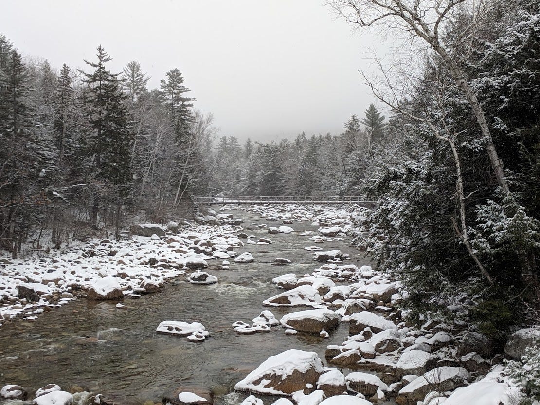
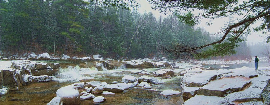
Personally, I prefer taking those gambles during seasons when other hikers are more likely to be around and in earshot of my profane cries for help. On my last midwinter visit to Sabbaday Falls, I ended up driving further eastward toward the Conways, so that I could finally lay eyes on a subtler water feature that’s mobbed in the summer. Lower Falls is more like a series of frothy rapids in the Swift River, occurring where the waterway starts descending into the valley. The roadside rest area beside Lower Falls is one of the most popular points along The Kanc—a proven place for picnicking, sun bathing, and actual bathing on the toastiest days. It’s probably dreamy on an evening in July, and the heft of the river seems somewhat understated then; especially if rain has been in short supply. But each winter, when the rapids and mini cascades freeze solid, the chaos and violence of the Swift River (as Werner Herzog might say) become much more visible and compelling. Lower Falls, in its frozen form, is the opposite of some glassy waterway winding through the countryside. It’s a jagged mass of ice and boulders. The occasional exposed jet of water surging amidst the riverscape can look like an arterial wound. It’s beautiful, in its gnarly, disordered quality, and I was the only person standing there gawking at it on the afternoon in January when I paid my visit.
Maybe I’m overestimating how essential these eerie, quieting midwinter experiences are to New Hampshire residents and state leaders. Perhaps the 4,000 Footers and the spells they cast are the raison d’être for plowing and salting The Kanc each winter. 10+ years of writing about walking and outdoor adventure has made me keenly aware that staring at a chunky frozen river on a zero degree day is something of a difficult pitch. But even if the prospect of some good midwinter brooding doesn’t speak to you at the moment, the year-round accessibility of The Kanc keeps that door open; should you change your mind one day. Our impulses and needs can transform unexpectedly, and what we do with our time outdoors is no exception. The idea of winter camping used to make me shudder. The thought of arriving at a tentsite, liberally marinated in sweat after hiking and crawling into a sleeping bag to stay warm, was repellant to me. But when my friend and hiking comrade Laura floated the idea of getting our feet wet with an overnight hike up to Mount Kearsarge near North Conway, something shifted in me. The prospect of a new, shared experience with someone whose company I like was enough to make me re-evaluate my strong feelings about winter camping. What made this possible is the fact that Kearsarge isn’t just there—it’s also easy to get to.
So my hat is off to the Granite State for resisiting its more libertarian-ish impulses and making it possible for people from all manner of backgrounds to experience The Kanc and its frost-burnt gems each winter. It’s easy to imagine a parallel universe in which the state allows the Kancamagus Highway to get so powdery and iced up that it’s only passable with snowshoes and quads of titanium. Luckily, despite the challenges we’re facing right now, we still live in a reality where this corner of the world is considered too enchanting and essential to lose for a quarter of the year. For that, I’m Kanc-ful.
Winter hiking is so special. Winter driving is daunting but sounds like NH makes it safe and beautiful.
What a pun you treated us to in that last line! Pow.