


Of all the forces and objects that have taken a destructive toll on cities, it’s tough to beat highways. In U.S. cities, highways will often cleave through entire neighborhoods, subjecting residents to relentless air and noise pollution. Worse yet, the decision to route these highways through residential neighborhoods was often rooted in racism. During the post-war Urban Renewal era, the homes of Black families were seized by the government through eminent domain and razed, in order to clear space for the interstates. In Boston, hundreds of families were displaced from Roxbury, Jamaica Plain, and adjacent areas during the 1960s, as the federal government prepared to fund the construction of the Southwest Expressway—an extension of I-95 that would have run 8 miles from Canton to the South End. It would have dismembered Boston.
But it was never built. That’s because a large consortium of activists who would later become known as the People Before Highways movement successfully pressured Governor Francis W. Sargent to call the project off. It was a victory in the wake of a tremendous loss, as scores of homes and small businesses had already been razed to make room for the highway. And what the state ended up building instead of the interstate extension was the Southwest Corridor—a multi-use greenway path, flanked with shade trees, following the MBTA Orange Line tracks from Forest Hills station to Back Bay station. Today, the corridor is one of the great walkable gems of Boston. I’ve traversed the Southwest Corridor innumerable times, on dates, on training runs, on my way to the Reggie Lewis track center to get my first COVID-19 vaccine, you name it.
But the Southwest Corridor wasn’t the only green gift that took root in Boston after the highway upheaval. Remember, the I-95 extension was going to extend all the way from the heart of Boston to Canton, on the southern edge of the city. And hidden within the woods and wetlands near Boston’s southernmost limits today, a forgotten segment of the planned highway that actually made it to the paving stage is now overgrown with vines and shrubs, but still accessible by foot. It serves as an unlikely connection to one of the most ruggedly charming hiking destinations in Greater Boston—the Blue Hills Reservation trail network—and this weekend, I’m going to show you the way in.
For all its craggy majesty, immersive bliss, and fighting rattlesnakes (seriously, there’s a video of this), the one sore spot of the Blue Hills Reservation is its accessibility. It’s located next door to the residential hub of Masschusetts and yet, it’s still tough to get to the trailheads without a car. The roads that wind through the core of the reservation are too narrow and bustling for walking. You could bike on them, but only in the same way that you could try driving a compact car on a logging road that’s full of potholes and semi-trucks screaming past you at 70 mph. And since none of the Blue Hills trails are serviced by MBTA buses, you pretty much need your own car to go for a hike here.
This may finally change in the next few years. The Metropolitan Area Planning Council of Greater Boston has been mapping out a new, connective greenway that would run a few miles from Boston’s southernmost neighborhoods, Mattapan and Hyde Park, to some of the most popular trailheads within the reservation. Being able to comfortably stroll or bike from Boston into the heart of the old woodlands would be huge. But it’s going to be at least a couple of years before this access dream is fully realized. In the interim, walking from Boston into the Blue Hills is going to be more of an adventure. I had been thinking about embarking on this adventure back in the spring: identifying a public transit station that was somewhat close to the western end of the reservation, where Great Blue Hill itself is located, and finding a safe-ish way to get there by foot.

Poring over maps, I saw something promising, about 10 minutes from the Readville commuter rail station by foot. It was a long pathway identified as the “Burma Road Trail.” It began from a tiny parking lot on Neponset Valley Parkway and followed the Neponset River itself in a long, straight, southwesterly line through a large patch of green space that I had never visited before. And toward the end of the trail, a dense maze of connector paths and service roads appeared to offer a direct connection to the westernmost trails of the Blue Hills Reservation. I hemmed and hawed. The trail would be heavy on wetlands, and since I hadn’t heard of the Burma Road Trail, in all my years as a Boston resident, I suspected it would be replete with signs of overdue maintenance: decaying bog bridges, flooded trail segments, etc. Furthermore, it was late May, the beginning of black fly season in Massachusetts. But despite all of this, the thought of being able to amble from the city to a pine-scented hilltop tower from which I could gaze at the cityscape had sparked a fire in my loins. I had to try this.
So I tossed some tortilla chips and bug spray in a backpack, made my way to South Station, and boarded a Providence-bound train, on a glowering Sunday morning. A quick ride to Readville and a comparably efficient walk along the parkway (which, thankfully, offers plenty of sidewalk) brought me to the little Burma Road trailhead, where two cars were taking up most of the available space. I was heartened to know that I wouldn’t be completely alone out here, as I stepped into a grove of deciduous giants and squelched my way along the beginnings of the trail. What began as a twisty path through the trees soon widened into a bushier tunnel of greenery, with enough clearance overhead to steal the occasional glow of sunlight. I had reached the long straightaway segment of the trail, and it couldn’t have been three minutes before I glimpsed a fellow hiker up ahead, walking their dog. This posed a dilemma that’s common in hiking. Our paces were just enough out of sync that if I continued at my normal speed, I would be trailing the hiker by only 10 feet, which would probably seem rather creepy. But if I wanted to overlap the hiker and continue ahead of them, I would have to power walk and turn my exploratory ramble into a full-on HIIT workout.

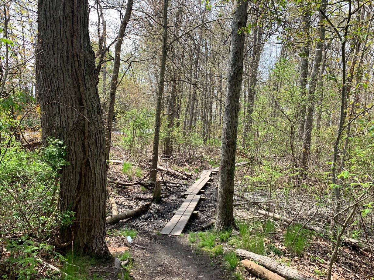
Eventually, a spur path on the side of the trail made the decision for me. The hiker took a hard left onto this sidepath, clearing the Burma Road Trail for me. I followed the trail for a solid 20-30 minutes, trying to hear the sound of the nearby river which was completely obscured from sight by all the wetland vegetation. But the wetlands themselves started to open up as I continued southwest, allowing lovely flashes of their fragrant waters and half-submerged trees. I checked my map upon reaching a second cut-off path—the one I was looking for. This path featured a rickety wooden bridge that led me into a pocket of forest that more closely resembled the Blue Hills territory where I was heading. And as I arrived at a brushy clearing within this forest, everything changed and I suddenly understood what exactly I had been walking on.

The ground beneath my feet had transitioned from dirt to weathered pavement. It was a lost road that stretched ahead of me for several hundred meters. And at the far end of this ancient road, from which tall grasses and prickers had sprouted up through the cracks, l could see the traffic of I-95—the highway which had almost crippled Boston. This paved corridor was the beginning of the end that never came. If the project had been completed, the interstate extension would have continued along what’s now the Burma Road Trail, before plowing through residential Boston. The sight of the lost link overtaken by greenery reminded me of the Planet Of The Apes movies, in a few ways. In those films, the end of human civilization has yielded a resurgence of nature, with burnt-out skyscrapers and freeways festooned with leafy plants. It’s a thing of beauty, built on a nightmare foundation. And what the apes have done with that foundation is also kind of beautiful. They’ve created thriving and sustainable communities. It’s only when factions of the apes start to mimic the megalomaniacal impulses of mankind when things start to get ugly again. Standing on the forgotten I-95 extension today is like visiting a battlefield on which the scars are still visible, while nature itself heals.
What happened next cemented the Burma Road to Blue Hills hike in the hall of fame for one of my favorite hiking genres: the “Am I Actually Allowed To Be Here…?” Hike. From the end of the paved road, I veered left into the trees again on a trail that hugged the edge of the woods and a clogged on-ramp for I-95. I could actually see the people sitting behind the wheels of these cars. One of them, a youngish guy in a white Honda CR-V, actually made eye contact with me through the windshield as I entered a denser, mossier stretch of forest. By now, faint blue blazes had begun to appear on the trees; a confirmation that I had crossed into Blue Hills land! As the grade of the trail started trending toward ascension, I prepared my lungs and calves for the denouement. Little Blue Hill, the far west bunny slope of the reservation, was my warmup. I scrabbled up the rocky path to the summit, sat on the memorial bench for Augustus Hemenway, and picked my way downhill to a sprawling parking lot on Washington Street. Here, I waited for a traffic window, dashed across the busy road, and picked up the Skyline Trail—the grueling 7.5-mile roller coaster of a trail that runs across the Blue Hills from west to east. I would follow the Skyline Trail a short distance to the top of Great Blue Hill, enjoy the city lookout from Eliot Tower, and kick off my return journey from there.

The climb to Eliot Tower from Washington Street is a Yankee ass kicker; a sequence of steep stone stairs and slabs, reflective of the northeastern idea that hiking should be a series of punishments. But these are brief punishments, and by the time I arrived at the foot of the big stone tower, feeling a gentle hand of wind sweeping through the trees around me, it was only 11:30am. I had managed to ramble from a Boston train station to the highest point in the Blue Hills Reservation—a moderately challenging hike of roughly 4.6 miles—and I still had an entire spring afternoon in front of me!
Before I tell you what I did with the rest of my afternoon—I’m guessing it’s a choice that most of you will not end up making—I need to end this story with a caveat. The Burma Road to Blue Hills hike can involve some serious mileage if you treat it as an out-and-back hike. If you start at Readville station, like I did, huff it to Great Blue Hill, and retrace your steps, you’re looking at a round trip of 9.2 miles. While most of the elevation gain is limited to the end of the hike, this might be more than some of you are looking to bite off. But there are two ways to trim the distance of the adventure.

Option A: Start the hike from Readville Station, hike to Great Blue Hill, descend to the nearby Blue Hills Trailside Museum (which has a pair of resident otters!) and call an Uber or Lyft from here. This is probably the simplest way to shave off several miles.
Option B: If you have a car, recruit a friend with another car, leave one vehicle in the parking lot by the Trailside Museum, and then drive over to the Readville area in the second car, together. Leave that car on a residential street near the train station, set out on the hike, and head home via the staged vehicle in the Blue Hills lot. While you won’t get the satisfaction of actually using public transit to reach the beginning of the hike, you’ll still get to reach a well-known place via an eerily beautiful forgotten path.
I didn’t do either of these things. Because I wasn’t ready to leave the Blue Hills behind just yet, having trekked through strange, forlorn wetlands and woods and lost highway corridors to reach the superlative summit. So I kept hiking, following the Skyline Trail due east, over every goddamn high point in the Blue Hills Reservation, all the way to the end of the trail in Quincy, where a 20 minute “cool down” walk to the closest bus stop would mark the end of my protracted, self-inflicted suffering. I’m not sure why I did this. It was an impulsive decision that left me limping for the next few days, as my lower limbs regained their strength and elasticity. But I couldn’t help but feel a sense of smugness, as many of us do after adventures that unexpectedly escalate. The hidden Blue Hills connector—our own lost highway—made my ramble possible.
Who knows where it might take you.

Readville Station to Great Blue Hill via Burma Road (one-way)
Hike distance: 4.6 miles
Elevation gain: 728 feet
CLICK HERE for a trail map
CLICK HERE for a Mass DCR map of the entire Blue Hills Reservation