

Four years ago, my friend and mentor Jay Heinrichs assigned me one of those stories that make the occupational pitfalls of writing feel like speed bumps. Writing for the Southwest Airlines in-flight magazine, I was dispatched to St. Louis, where I spent several days roaming the city with local Millennials who could speak the food and art scenes, the quality of life, and the creative energy that undergirds “The Lou.” The place charmed me, to the point where an offhand tweet I wrote about how much I enjoyed St. Louis sparked a St. Louis Post-Dispatch article about my visit to the city, which excited the publisher and left me with a huge flareup of impostor syndrome.
But there was one element of St. Louis that eluded me—something I had heard about in passing from my contacts there, but never got to explore firsthand.
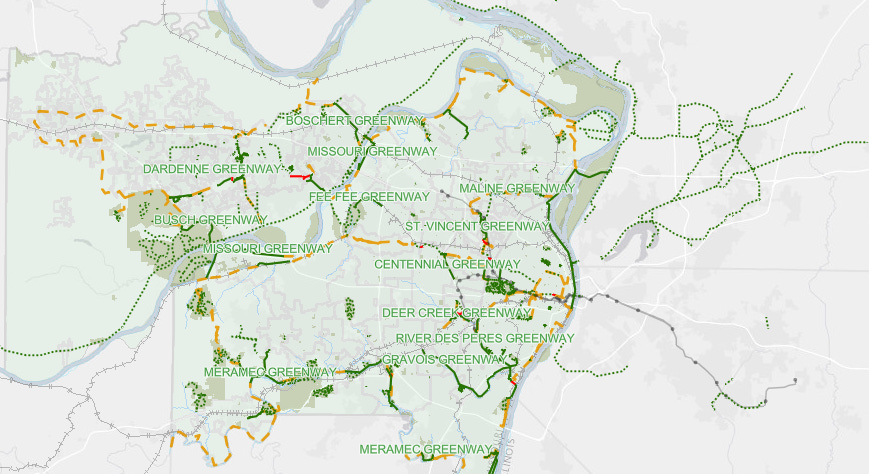
St. Louis has joined the list of U.S. cities making themselves friendlier to pedestrians and cyclists by investing in green transit space. Bike lanes and crosswalk expansions are two of the most common ways in which these infrastructure remixes manifest. But St. Louis is upping the ante by planning and building a network of greenways that will allow you to walk, bike, scooter, or pogo stick from one neighborhood to the next.
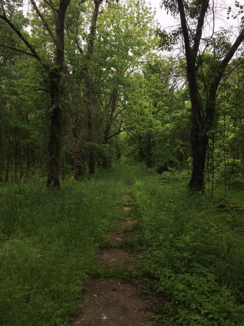
What is a greenway? It’s a multi-use paved path flanked with greenery that can range from shrubs planted around an industrial zone to a thick forest swimming with ferns, vines, and deciduous trees. Frederick Law Olmsted pioneered the idea with his linear park systems in Buffalo and Boston, but before it could really take off in more cities, the automobile arrived and took center stage among city planners.
St. Louis is one of many American cities where cars have long reigned supreme and the greenway project—which is being managed by Great River Greenways—aspires to restore some pre-automotive peace, safety, and balance to intercity mobility. More than 128 miles of greenways have already been built in the St. Louis region and over the next few years, some of them will be connected with the addition of new paths.
Nearly half a decade since my first Lou layover, I was finally headed back to the city to attend the wedding of two dear friends. But before putting on my suit, I had to go and hike one of these St. Louis greenways. Poring over the Great River Greenways project maps—which show finished and mid-construction paths—the menu of local greenways felt kind of like a scattered pile of emerald Legos, waiting to be clicked together into something grandiose. I wanted to experience what it might be like to hike from one St. Louis destination to another, even if it required street walking from the end of one completed greenway segment to the beginning of the next segment.
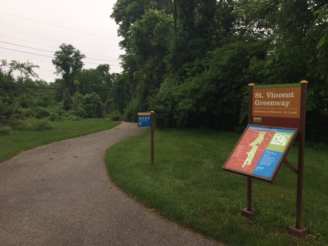
I chose the St. Vincent Greenway, which runs south from North Hanley transit center near St. Louis Lambert International Airport to Forest Park, the 1,300 acre beast of a park near the city center. Just imagine. You land at the airport, you hop on the Metro train and take it one stop east, and then you hike from the transit center to one of the most sumptuous parks in the Midwest, right in the heart of St. Louis. How many other American cities can offer that? Altogether, it would be a mostly flat 7.7 mile hike from North Hanley transit center to the Forest Park gates. But since St. Vincent Greenway is divided into two sections, my hike would also include a 2.8 mile walk on the streets of Wellston, a working class neighborhood near the northern boundary of Forest Park.
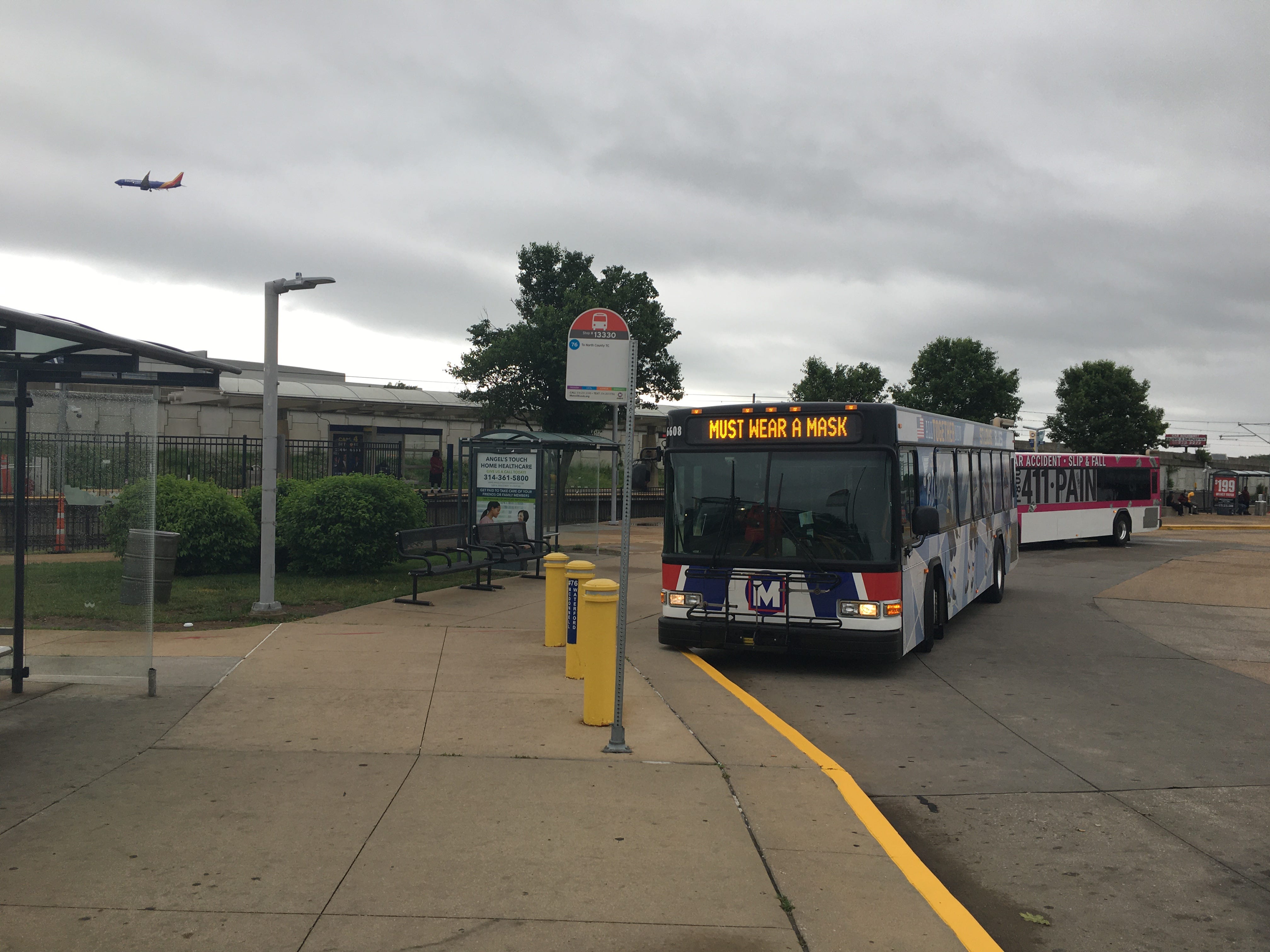
Setting off early on a Saturday morning, I rode the Metro red line train to North Hanley and disembarked under apocalyptic dark skies. The forecast was calling for severe thunderstorms in the late morning. It was 8:30am. Noting that St. Vincent Greenway passed through the campus of University of Missouri St. Louis, I figured that I could take shelter in a campus coffee shop as the monsoons arrived and continue the hike once they had passed. The north greenway trailhead is located off a residential street called Marlin Drive, right across from the transit center. But to get there, I had to dash across a roadway that would have been much busier on a weekday. It struck me as ironic that the final connection between a greenway and a transit center didn’t include any crosswalk. But I suppose that speaks to the nascent state of St. Louis greenways.
The paved path of the St. Vincent Greenway snaked through some impressive woods on the side of the busy roadway before veering south and burrowing right into through university campus, which felt like an abandoned city with graduation having passed. I ambled past football fields, lots of shade trees, duck ponds, and at one point, a pair of Canada geese that hissed at me as I noticed their goslings. All the while, the sky continued to glower and occasionally rumbled with thunder and a flare of lightning.
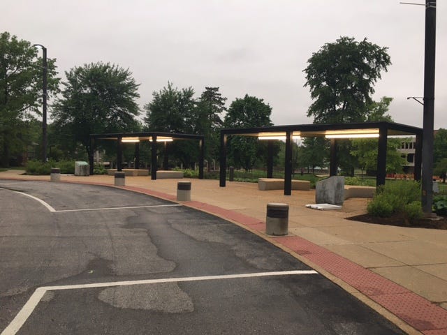
I was getting nervous. My coffee shop plan hadn’t accounted for the fact that UMSL campus would be more or less shut down. As the sky became darker and the timing between lightning flashes and thunder narrowed, I decided to seek shelter. A pair of lighted bus stops seemed like an appropriate place to ride out the first storm, which drenched the area with crashing rain and lightning so frequent that it brought to mind Berlin’s dirtiest clubs. I waited in the bus shelter for over an hour but the storm was relentless. Every window between downpours lasted only a few minutes and once it became clear that the deluge was going to last all day , I realized I would have to bail on the hike and pick it up the next day, before the wedding. As the lightning finally began to wane, I sprinted half a mile through rain to the closest Metro train stop, on the south end of campus, and planned to return here once the thunderstorms passed. Even an urban hike can be upended by inconvenient weather. But jumping on the bus or train is highly preferable to scrambling down an exposed ridge toward the treeline.
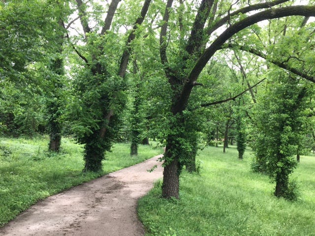
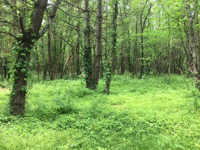
The following morning, I returned to the bus stop shelter and picked up the St. Vincent Greenway again, following it to the southern edge of the UMSL campus and into the meadows and forests of St. Vincent Park—the grounds of a former Catholic hospital that went the way of the dinosaurs in the 1980s. Some of the neat features of the park are the traces of history that remain here, like forgotten sidewalks that disappear into the resurgent forest, or the Daughters of Charity cemetery whose closed entry gates are spaced wide enough to allow the passing hiker to slip inside and walk among the headstones. As the woods became more immense, the trail descended into them by way of weaving switchbacks and the immensity of the green colors here stunned me. It spoke to what a wealth of natural green space St. Louis is tapping into once again.
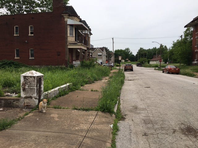
If the passage through St. Vincent Park enchanted me, the midsection of the hike was a bit of a comedown. The northern greenway segment ends at St. Charles Rock Road, another stressful roadway that you have to run across whenever there’s a wide traffic window. (With pedestrian deaths on the uptick, you really want to give yourself a very wide window these days, which can require quite a bit of waiting to cross.) Once I hit the quiet Ferguson Avenue, the street walk became a more meditative affair, passing some very tall electric towers and a couple of community gardens. As I crossed into the West End and approached the second leg of the St. Vincent Greenway, a solitary cat nodded in my direction as I passed its house. Usually I’m far more conscious of angry dogs when walking through residential areas, but this cat looked like a creature of civic authority, so I was grateful for its tolerance as I picked up the greenway again.
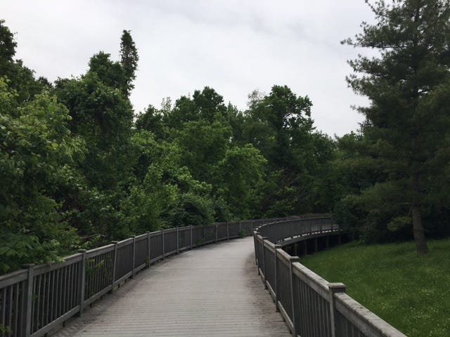
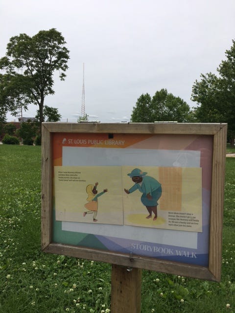
Much like the Commonwealth Avenue Mall in Boston, the southern segment of the St. Vincent Greenway is basically a long straight-shot of a green path through residential homes and buildings with Forest Park waiting at the end. The path winnowed south past robust trees and sculptures by local artists. One featured that I was especially fond of was the St. Louis Public Library’s “Storybook Walk” exhibit, where display cases on posts showcase the pages of a storybook that you can read as you walk along the greenway. (This week’s featured book was Mommy’s Khimar, by Jamilah Thompkins-Bigelow and Ebony Glenn.) I was also enamored with the leafy alleyways that the path would regularly cross. I would have gladly taken a detour and ventured down one of those alleyways if my fear of toothy territorial pets hadn’t stopped me.
The final hike from St. Vincent Greenway to the northern Forest Park entrance follows the tracks of the STL Loop Trolley, a historic streetcar which runs through the Delmar Loop near Washington University. The trolley wasn’t running, so I walked on the tracks themselves, gazing ahead as the fountains and old arbors of Forest Park got bigger.
I was tired and almost intimidated by the scale of the destination. You could spend an entire day wandering the wooded paths, wildflowering fields, and ponds of Forest Park. In fact, the wedding I was attending was being held in the park that evening!
So three hours after finishing my hike at the park entrance, I was back, walking into Forest Park toward sundown in my suit, with dress shoes that had seen their prime during the Obama years. Looking out at the park from the World’s Fair Pavilion that evening, meeting new people with a pale ale in one hand and an iPhone set to camera mode in the other, I noticed how everyone inevitably commented on the immensity of Forest Park and the fact that an enormous green space like this could exist in a city.
Just wait until the St. Louis greenways are finished.
THE RUNDOWN
St. Vincent Greenway
Leg 1: North Hanley transit center to St. Charles Rock Road - 3.6 miles
Street walk midsection - 2.8 miles (or take the bus with the Transit app)
Leg 2: Etzel Avenue to Forest Park - 1.3 miles
CLICK HERE for a trail map
The greenway sounds lovely but St. Louis should do something about those dangerous street crossing problems!