

Paul Greengrass, a former journalist who’s now the director of Captain Phillips, United 93, and Bloody Sunday, is one of my favorite filmmakers. He’s able to tell stories that are hyperlocal in their viscerality and at the same time, international in their reach. His depiction of the days-long standoff between freighter captain Richard Phillips and Somali pirate Abduwali Muse (played brilliantly by Tom Hanks and Barkhad Abdi) is a story of two men from different walks of life finding themselves in the meat grinder of militarized globalization. It’s also an absolute nerve-shredder of a high seas thriller, in which each gunshot and every drop of sweat feels real. A post-film drink is necessary.
So last February, I found out that Greengrass was making a movie about the deadliest wildfire in California’s recorded history (thus far) I began sweating with anticipation.
Several months later, that movie is out on Apple TV+ streaming and in select theaters. It’s called The Lost Bus and it brings the 2018 Camp Fire to life through the true story of a school bus driver (Matthew McConaughey) and a teacher (America Ferrera) who find themselves in the path of the inferno while attempting to transport 22 kids to one of the evacuation zones near Paradise—the mountain town that was consumed by the horrific wildfire. Sparked by failing utility infrastructure that Pacific Gas & Electric had neglected to repair, the Camp Fire swept across the arid landscape and swelled into a gargantuan monster quicker than anybody expected. The town’s evacuation protocols proved fatally insufficient, as traffic immobilized the roads and firefighters with limited resources switched their priority from putting out the blaze to saving as many lives as possible. Many of the 85 people killed in the Camp Fire were burned inside their cars.
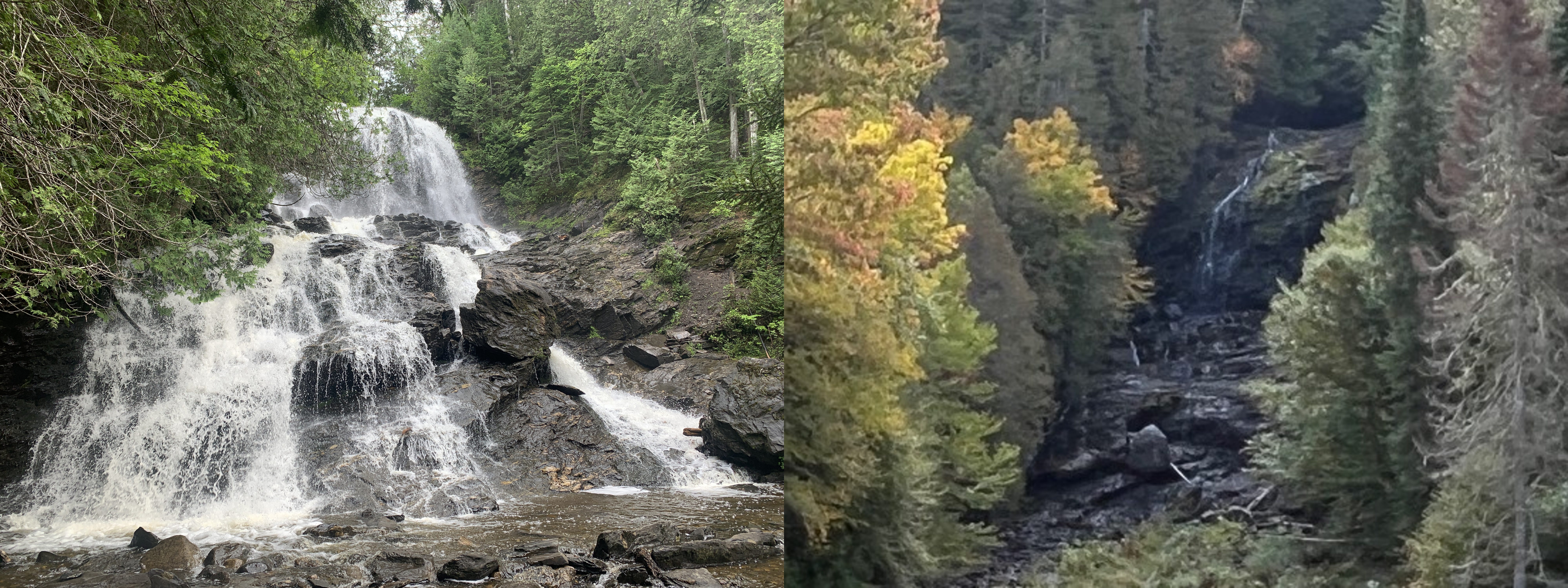
You don’t have to live on the west coast for the events of The Lost Bus to feel close to home. That’s because several regions of the U.S. are currently in a state of drought; including New England, where I live. A few weeks ago, I was in the far north of New Hampshire taking photos for my upcoming guidebook on fall foliage trips. I decided to swing by Beaver Brook Falls, a thunderous gusher of a cascade near the town of Colebrook, and what I saw shocked me. The waterfall—an 80-foot wall of whitewater—was gone. All that was left was a damp cliff. I texted a photo of the parched cascade to my friends Natalie and Adam, who own a house nearby. “WTF” Adam responded.
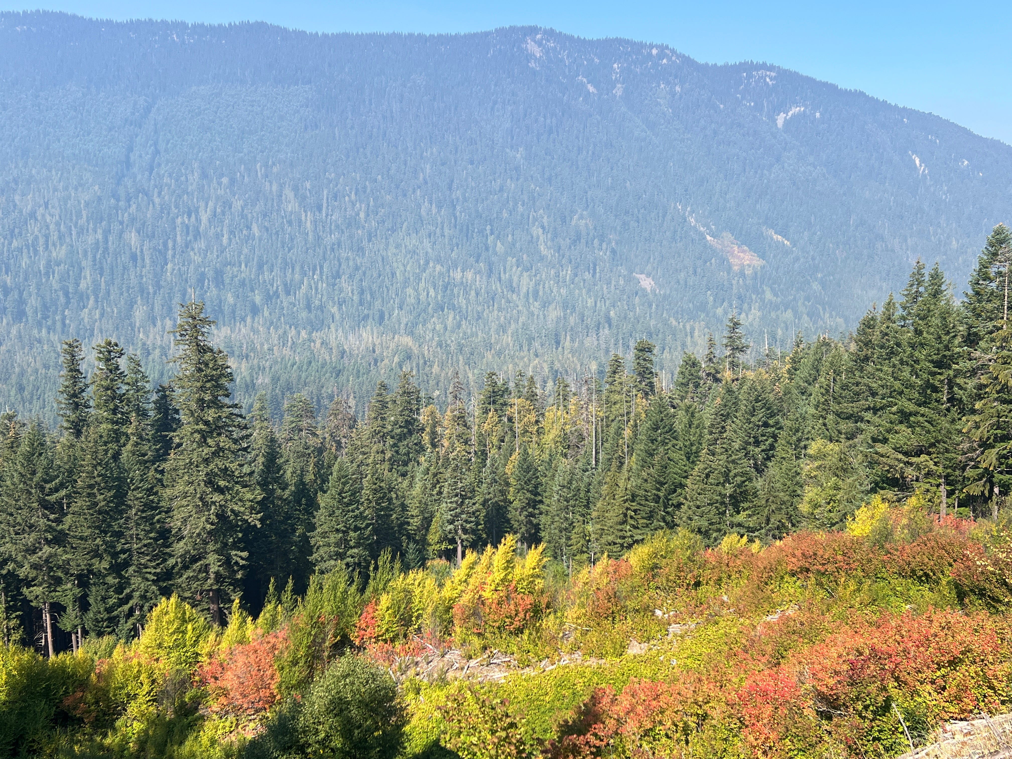
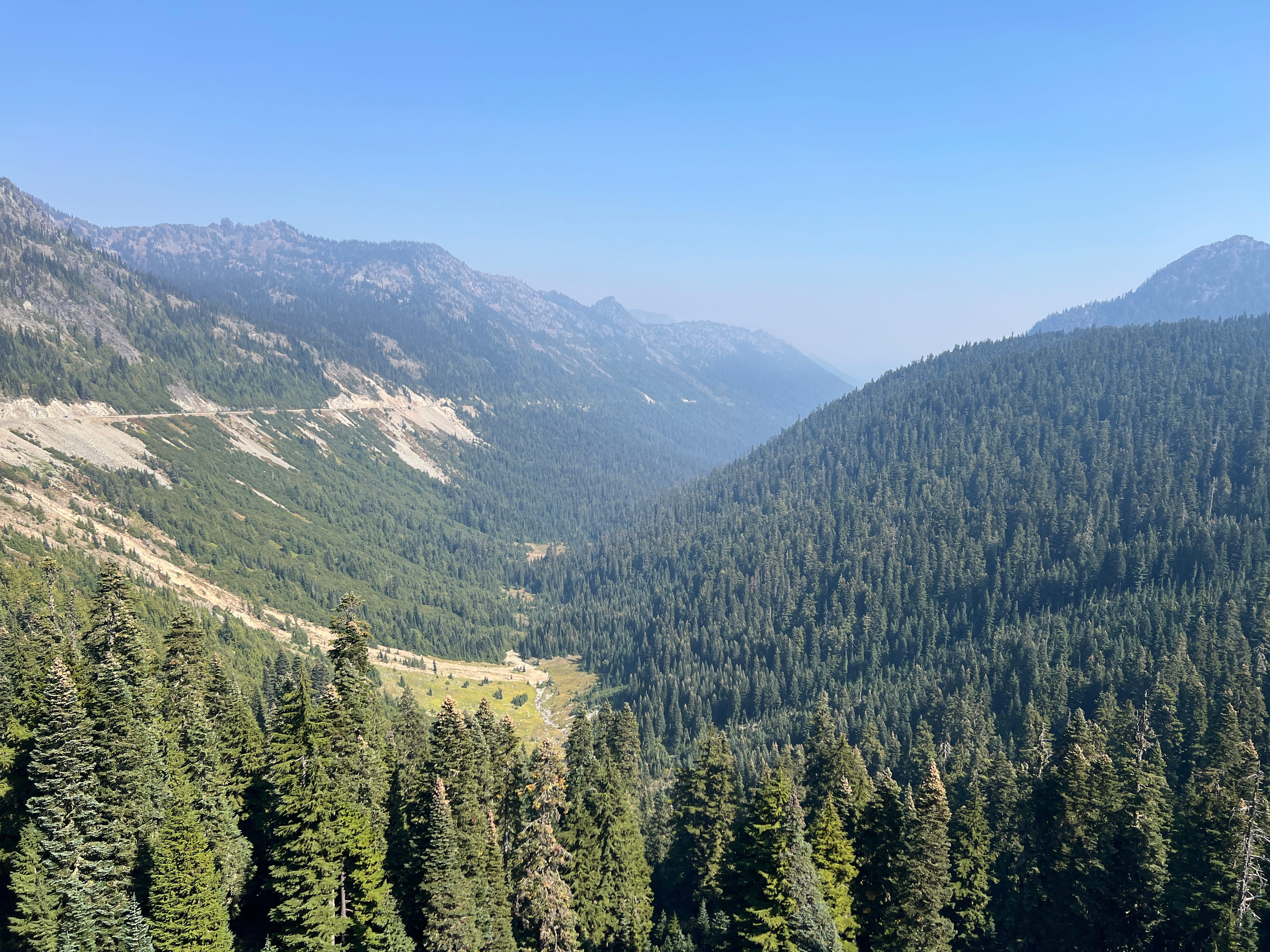
Less than one week after bearing witness to the vanishing of Beaver Brook Falls, I was on the other side of the U.S., driving east on the Chinook Scenic Byway to Mount Rainier. The Chinook road is one of two scenic byways that wrap around the gigantic cone of Rainier; making for a perfect 48-hour road trip, with a night in the high desert city of Yakima on the mountain’s east side. While evergreens are the dominant genre of tree around Rainier, there are plenty of larch conifers that take on brilliant hues of gold and yellow during fall. And that’s what I had flown out here to photograph. But as I walked through coniferous woods on the trail to a cascade called Skookum Falls, I noticed something odd when I came to a clearing and took pictures of the adjacent White River. The angle of the morning light was just right for capturing the river in its full color and texture. And yet, the images looked slightly foggy, as though invisible condensation had built up on my camera lens. The same thing happened when I tried taking photos of Skookum Falls itself. All of my pictures appeared mystifyingly hazy.
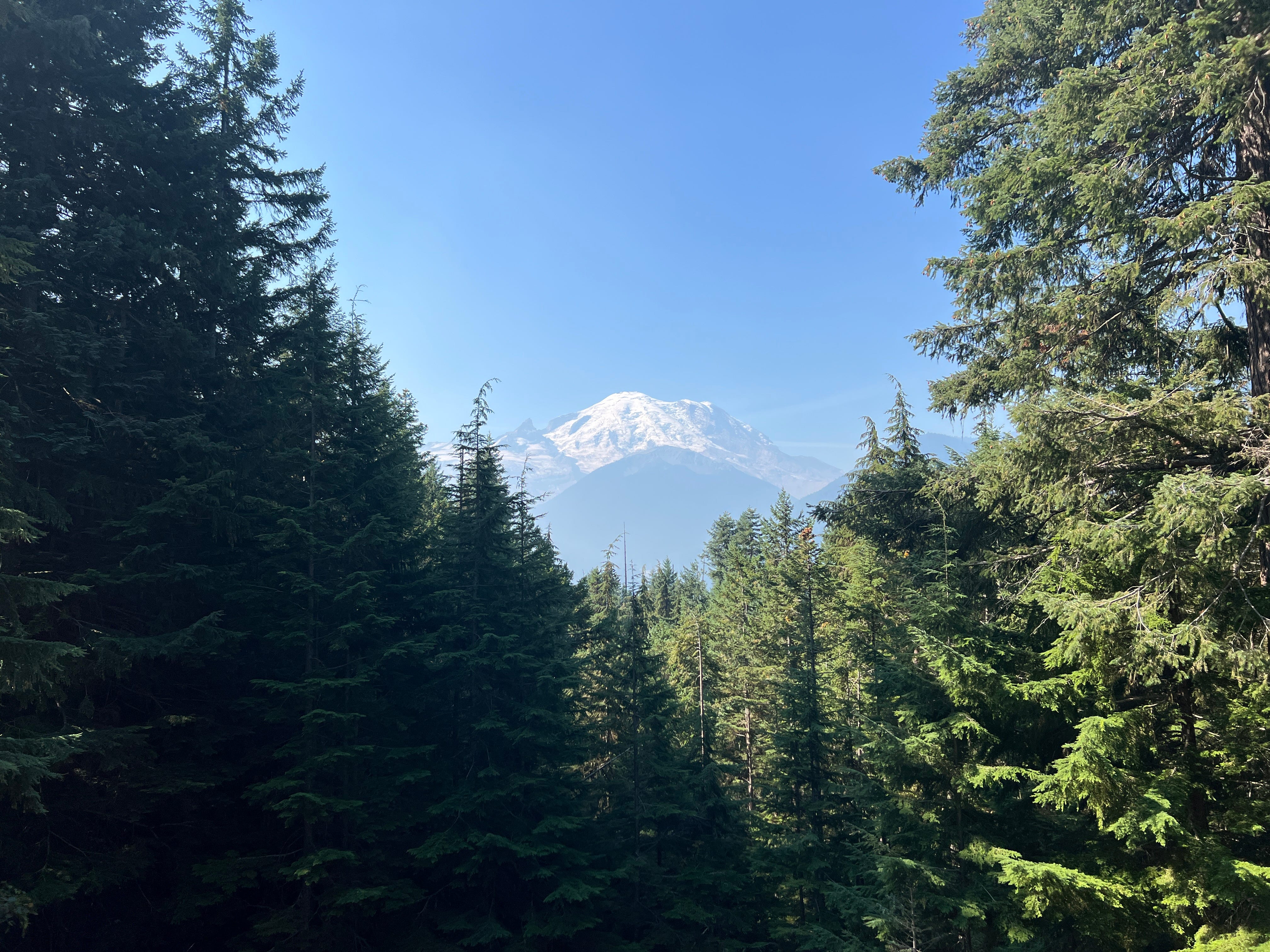
Gnawing concern that something was wrong with my camera equipment was how the anxiety of that day began. I kept driving eastward and began ascending the haunch of Mount Rainier. And just over halfway up to Chinook Pass—the titular high point of the scenic byway, from which the descent into Yakima begins—the snowcapped pinnacle of Rainier suddenly revealed itself through a gap in the pine trees. I frantically pulled over onto the shoulder, pleasantly surprised by the absence of other cars on the road. The nonexistent traffic behind me or ahead should have been a clue that something was amiss. But as soon as I got out of the car with my camera in hand, a much more obvious cue stopped me in my tracks. I could smell smoke. It was everywhere; a film of olfactory assault that partially obscured the vista of the woods below. Somewhere, in reach of Mount Rainier, trees were burning. And I suspected the wildfire was growing.
I was caught off guard. Earlier that morning, when I picked up my rental car at the Sea-Tac airport and set off for Enumclaw (the western start of the Chinook Scenic Byway) I hadn’t read or heard any mention of large wildfires burning in the Rainier vicinity. But then again, I hadn’t exactly searched for any fire reports; which I probably should have done, for a couple of reasons. The growing regularity of late summer and fall wildfires on the west coast is now a predictable natural hazard. And since I was a visitor to the region, and not a resident, I was not registered to receive wildfire alerts on my phone or computer. Now, on the upper reaches of Mount Rainier, with the aroma of smoke growing more intense by the minute, my cell phone was unusable due to the lack of service in the area. Should I go on? I wondered. Or do I hightail it back to Enumclaw?
The case for backtracking was the most straightforward. If there is a wildfire burning someplace nearby and you don’t know where it is or how large it is, retreating across territory where you weren’t encountering smoke or any other hints of a fire is a pretty safe wager. This was my initial impulse: get the hell out of the Rainier area, check the news upon re-gaining cellular service, and re-assess from there. Then, I wondered if I was overreacting. I had not encountered any signs on the Chinook Scenic Byway that warned drivers of a fire ahead. The fact that the road was still open seemed to bode well. And wildfire smoke can easily travel a great amount of distance in a short time. I might have been huffing the fumes of a blaze that was burning over 100 miles away.
But if I’m being fully honest here, there was a more problematic reason why I talked myself down from retreating—a motivation which is often the beginning of really bad decisions. Convenience. The haze of the wildfire meant that I wouldn’t be able to take many good pictures that day, which was fine. (Guidebook photos are usually a mix of original images and others licensed from third parties.) But I was out in the northwest doing my field research on a packed schedule and limited budget. If I headed back to Enumclaw and found out that the wildfire was large and close enough to pose a risk to the byway or City of Yakima—where I had a motel reservation for the night—then I would be vindicated. But if the fire turned out to be a non-issue, I would have added a few more hours of driving to a schedule that already involved lots of time on the road.
It sounds so stupid now, spelling out my internal reasoning. Alas, most of us are all-too capable of brushing off our own exposure to natural hazards, if it suits our plans. (Just look at the seemingly irrepressible market for coastal homes in the U.S.) A few more hours in a Hyundai Elantra that was too small for me would have paled to the agony of inhaling denser smoke or getting licked by flames. Still, I wasn’t completely oblivious to the possibility that continuing along the byway could mean getting too close to a wildfire. So I brokered a self-compromise. I would keep going, cautiously, and if I got cell service, I would stop, check for updates, and re-evaluate my plan. If I wasn’t able to find cell service further up the mountain, I would keep my eye out for any additional signs of a fire burning nearby; warning signs posted on the road, and worsening visibility due to smoke. If I encountered either of these, I would turn back.
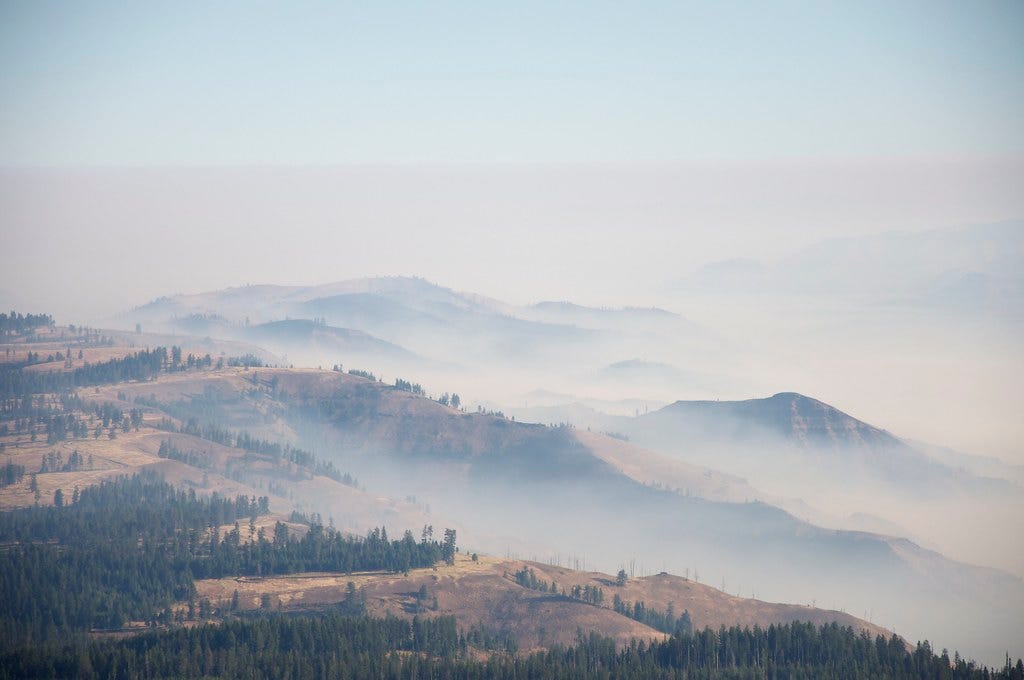
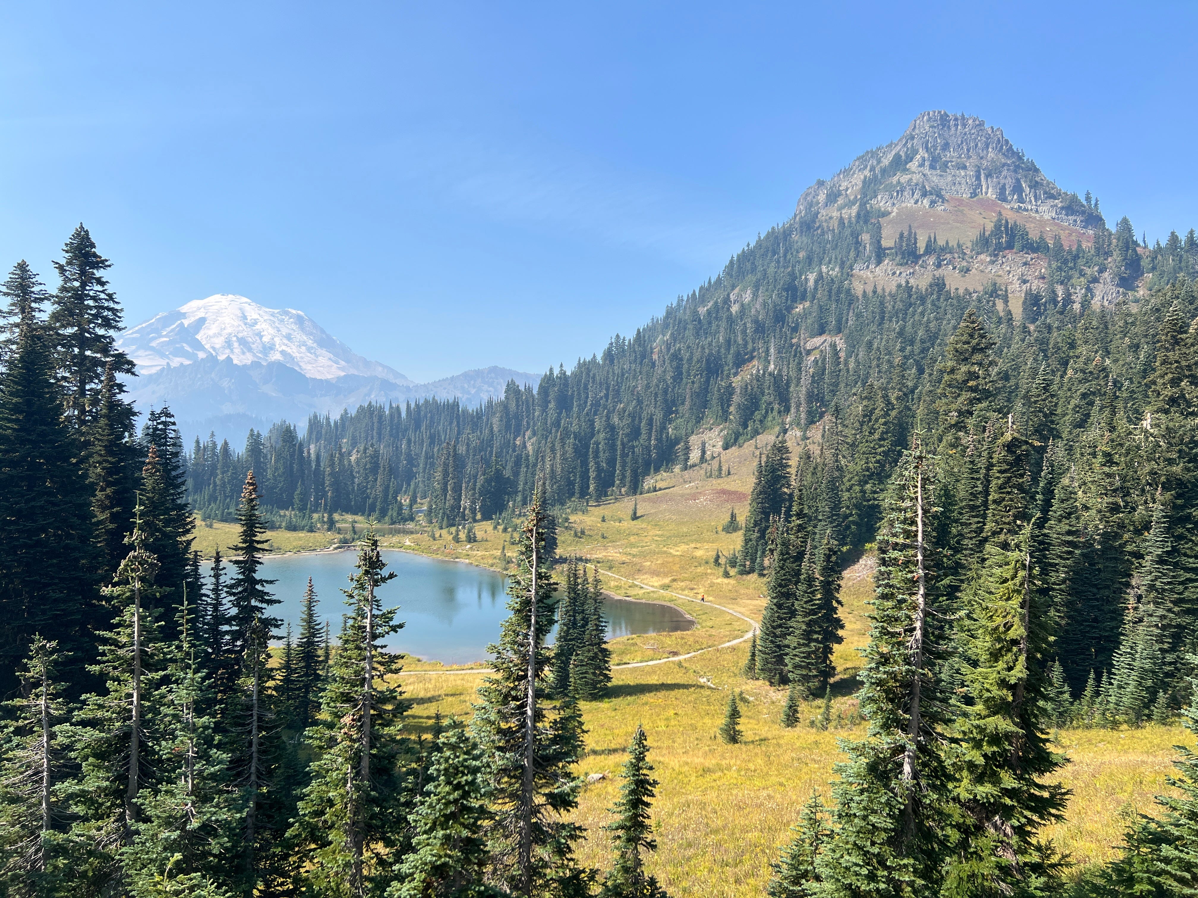
As I emerged from the trees and began the final switch-backing portions of road to Chinook Pass, I started seeing other cars descending the mountain in the opposite direction. This gave me some measure of confidence, even though the direction of those cars could indicate trouble up ahead. (None of them stopped to dissuade me from continuing onward.) And by the scenic overlook where you can gaze down at Tipsoo Lake, or hike down to its shoreline, there were other parked cars and visitors about, snapping selfies and acting normally. But when I finally got to the pass itself, I knew that my drive to Yakima was about to include a lengthy detour. The panoramic vista of the Naches Valley to the east was partially obscured by haze. The smell of the wildfire smoke up here was more overpowering. And an electronic sign staged along the byway warned travelers that further down the mountain—on the east side, where high desert reigns—sections of the Chinook Pass Byway were overwhelmed by smoke.
About an hour later, I rolled back into the smoke-free, service-rich town of Enumclaw and parked beside the Logging Legacy Memorial—a sculpture depicting two big oxen towing a felled tree. Five minutes of phone scrolling gave me a clearer picture of the situation. The inferno that I had been smelling was the Wildcat Fire; a 9,000 acre fire that had been burning in the nexus between Mount Rainier and Yakima for a couple of weeks. The day before my arrival, the fire had grown slightly and couple of adjacent towns had been placed on a higher level of alert; basically the “Get Ready To Possibly Evacuate” sage. I couldn’t find any mention of Yakima being in danger, so I called the motel to inquire about the conditions there. “No…there’s no smoke here,” the young desk clerk told me, as if I had asked him whether Wu Tang Clan was in town that night.
In the end, I made it to Yakima by taking a more meandering, smokeless approach on Interstate 90. I spent the magic hour sampling west coast-style IPAs in the garden at Single Hill Brewing, where families and young people were gathering for the weekly bingo night. There was no trace of smoke or haze in the evening air. As the host—a quippy entertainer who kind of reminded me of Bobcat Goldthwait—dropped off a bingo card and some gemstones at my table, the memory of detecting the wildfire and weighing my options seemed as far away as the east coast. But knowing that a forest and prairie were burning, less than two hours away from here, was difficult to shake. Before going to bed that night, I put all of my luggage in the trunk of the car.
In the years ahead, more of us will have experiences like this, out west, on the eastern seaboard, and in other places where people didn’t have to worry about wildfires until recently. It now seems inevitable that New England will experience a sizeable wildfire of its own, within my lifetime—given how little we’ve done to mitigate the effects of climate change. I have to hope that when or if that day comes, there will be plans for how we respond to that crisis and save lives. But as Paul Greengrass shows us in The Lost Bus, plans hinge on theory. Hotter summers, more expansive droughts, and the unpredictable recklessness of human behavior—whether it’s a utility giant allowing equipment to fail or a teenager throwing firecrackers into a gorge—cannot be fully planned for. Thousands, perhaps millions of us, will have to make snap judgments amidst circumstances that could range from slightly concerning to life threatening.
In the absence of a solution to this growing vulnerability, sharing our own stories of making risky decisions when we start smelling smoke seems like a good thing to do.
Last summer I was driving home from a hike in the Gunks on beautiful winding back roads through the mountains around Sterling Forest when I started to smell and then see smoke. I had heard about a fire in southern New York northern New Jersey, but hadn’t really noticed where it was. I knew it sounded really bad and then I suddenly realized I was headed right into it. Even with the windows in my car closed and the air on recirculate, it was getting suffocatingly smoky in my car. The visibility was down to very little. I did not turn around as I should have, but it was a narrow winding road with basically no place to turn around. I never actually saw flames but I know they were close. It was so sad to think about all the creatures in there…so many didn’t survive.
Thank you for this essay. My family lives in the Northwest and I was out there this month. It's scary how smoky it is nearly all the time now. I love the region but now am glad to live in New England. But as you say, we are all facing the unknown these days.