
Trails, Trams, Trains, and Trolleys
Multi-modal magic on Portland's ingenious 4T Trail

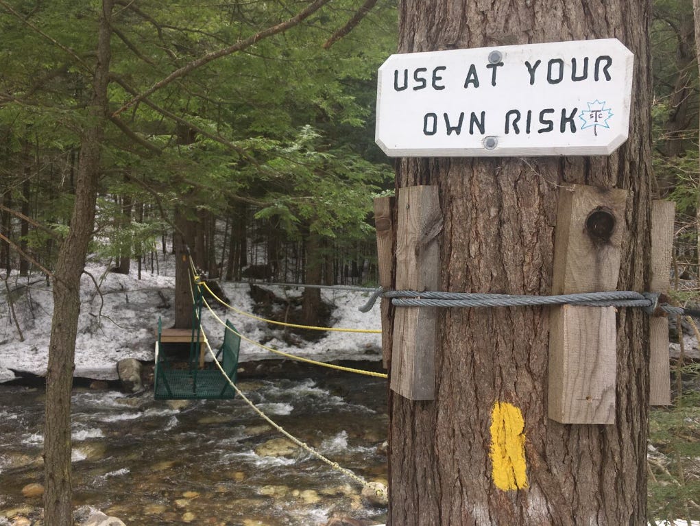
You know what’s great when you’re on a long, scenic walk someplace where the birds are screeching and the grasses are rolling like an ocean? Not walking, but still moving. Take the Stockholm Archipelago Trail, which runs 167 miles across 21 islands. When it’s time to hop from one island to the next, you step aboard a ferry or climb into a row boat, make your way across the water, and resume your hike. Closer to home, there’s something special hidden in the northeast edge of the White Mountains; a cable car strung across Austin Brook, which you have to cross when hiking to Dryad Fall. You need to use a rope to pull the car over the brook, which offers a nice change of pace from negotiating the rocks, roots, and puddles that New England trails are made of.
But what if you could create something like this on an even mightier scale? A Planes, Trains, and Automobiles style trail that combines different modalities into one route? We tend to think of trails as venues for singular activities—usually walking or biking. And yet, when we’re walking around the places where we live (cities especially) we’re often mixing and matching modes of transportation. You walk to a subway station, ride the train across town, walk another couple of blocks to your date’s place, and then the two of you pick up rental bikes and pedal to your favorite park to picnic and make out. Maybe you catch a ride home, or perhaps it’s such a beautiful night that you walk.
Again, what if this could be a trail?
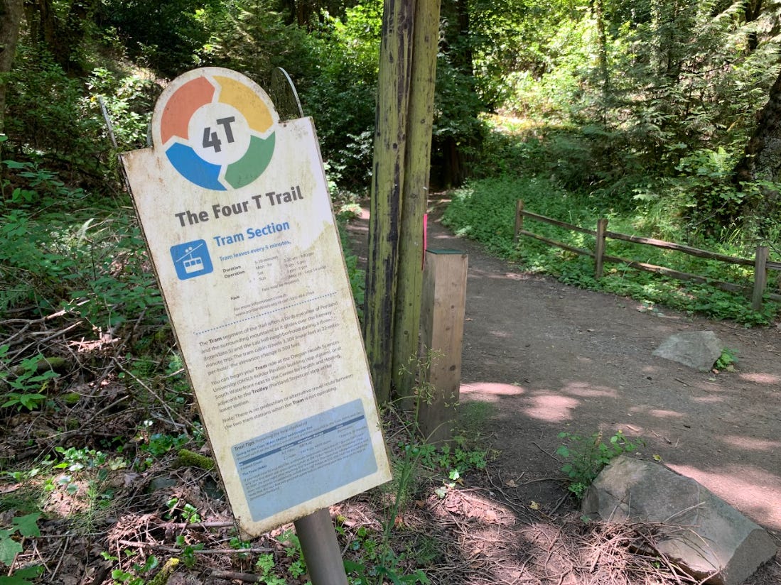
The next time you find yourself near Portland, Oregon, you don’t have to wonder about this. Because in the late 2000s, a local father and son duo created the 4T Trail, a loop around the west side of the city that features four methods of movement that begin with the letter T. The lion’s share of the route is a series of Trails through the wooded hills and ravines near Homestead and Portland Heights. Then, you ride an aerial Tram down to the edge of the Willamette River. From there, the MAX Trolley takes you into the heart of Downtown Portland, where you close the loop by catching the Train to the Oregon Zoo (from which you started the woodland Trails portion.) I’ve spent a lot of time poking around urban trails in the U.S. and aboard, and I’ve never seen anything quite like the 4T Trail elsewhere. Even more remarkable is the fact that the founders, Don and Eric Baack, were able to persuade the City of Portland to fund infrastructure for the 4T Trail, such as metal signs that you’ll find posted along the route. While it didn’t happen overnight, this is a striking breakthrough, as city governments can be aggressively wary of urban trail concepts that they didn’t come up with themselves.
I’ve got family in Portland and before learning about the 4T Trail, I had already spent some time on each featured modality. The idea that you could combine them into a hiking route fascinated me; not just because I’m one of those Millennial transit nerds who goes weak in the knees for a train connection in a forested area, but because the multi-modal trail—if embraced and realized in more places—could change the way we think about hiking and trails in general. Treating a more passive means of movement like riding a trolley as part of a trail experience expands the scope of who can enjoy a trail. In most cases, stepping from a literal built trail onto a train would signal the end of a hike; or in some cases, bailing on a hike. But when that train is just as much part of the adventure as the sauntering and scrambling, climbing aboard no longer comes with a sigh of relief or defeat. The train suddenly gleams with intrigue and possibility.
I know this because last summer, I paid a 36-hour visit to Portland on my way to see friends in Seattle, with the intention of checking out the 4T Trail for myself. I prepared accordingly by eating a McIsley breakfast sandwich (fried chicken, pickles, mustard, and honey) from Pine State Biscuits, before catching a city bus from the east side of the river to downtown. There I would kick off my 4T traverse with the Trolley segment.
While you could start the 4T Trail from any point, I was fixated on two things. I wanted to feel the satisfaction of climbing high into the hills, without doing any cardiovascular work, and this meant that I would have to take the Tram up to the Trails. I also fancied the idea of finishing the 4T Trail within walking distance of nourishing lunch options, like the pork and sugarcane shrimp vermicelli bowls at Luc Lac Vietnamese Kitchen. Jumping onto the Train after finishing the forest Trail chapter would allow me to end up back in the heart of the city, where the restaurants and bars are most concentrated.
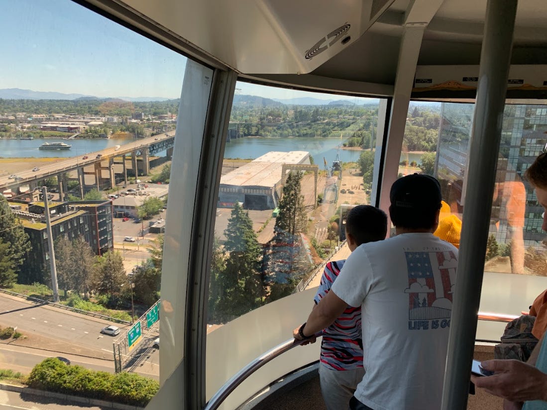
Now in the interest of properly setting expectations, I should say that the magic of the 4T Trail didn’t take hold immediately. From the MAX station at the intersection of SW Morrison Street and SW 11th Avenue, the trolley headed south toward the water and it felt just like that; a trolley ride through an increasingly pavement-heavy stretch of the waterfront. As far as I could tell, I was the only rider aboard the trolley wearing hiking boots and carrying a backpack and a trekking pole. But it wasn’t until I disembarked and approached the ticket window for the Portland Aerial Tram when I started to feel the crackling excitement that manifests when you’re going someplace unfamiliar. The towering height of the tramway surprised me and as I watched one of the gondolas descend toward the station, a thought crossed my mind—a thought which has never crossed my mind in the middle of a hike. In three minutes, I am going to be airborne.
An aerial tram is a special offering that does not appear on the average city menu of mass transit options. If you’re in Portland, a ride up or down the scenic tram is worth every penny, given the views of the city, the river, and Mount Hood. I took all of this in with about 20 other passengers crammed into the bubble-like gondola, and even the kid in front of me who had been glued to some superhero game on his iPhone was eventually taken aback (quite vocally!) by how high we were now soaring above the cityscape. I’m not sure if Don and Eric Baack always envisioned the tram as being a part of the 4T route, but it wouldn’t surprise me if the entire concept grew from here; from wanting to create a trail that included a ride on the aerial tram. If you’re going to create a multi-modal trail, you should incorporate the coolest options for mobility. In San Francisco, that would mean cable cars. In New York, you could throw a horse drawn carriage ride in the mix. And in Lisbon, a funicular lift would be a no-brainer.
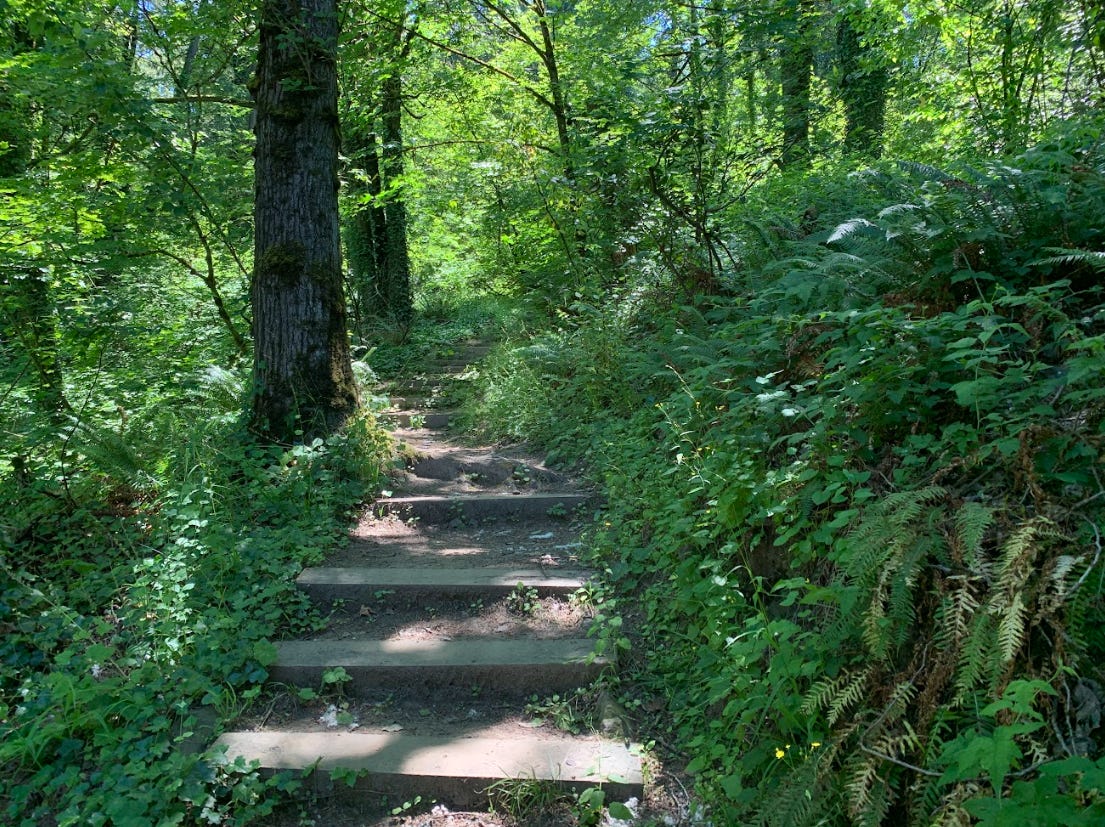
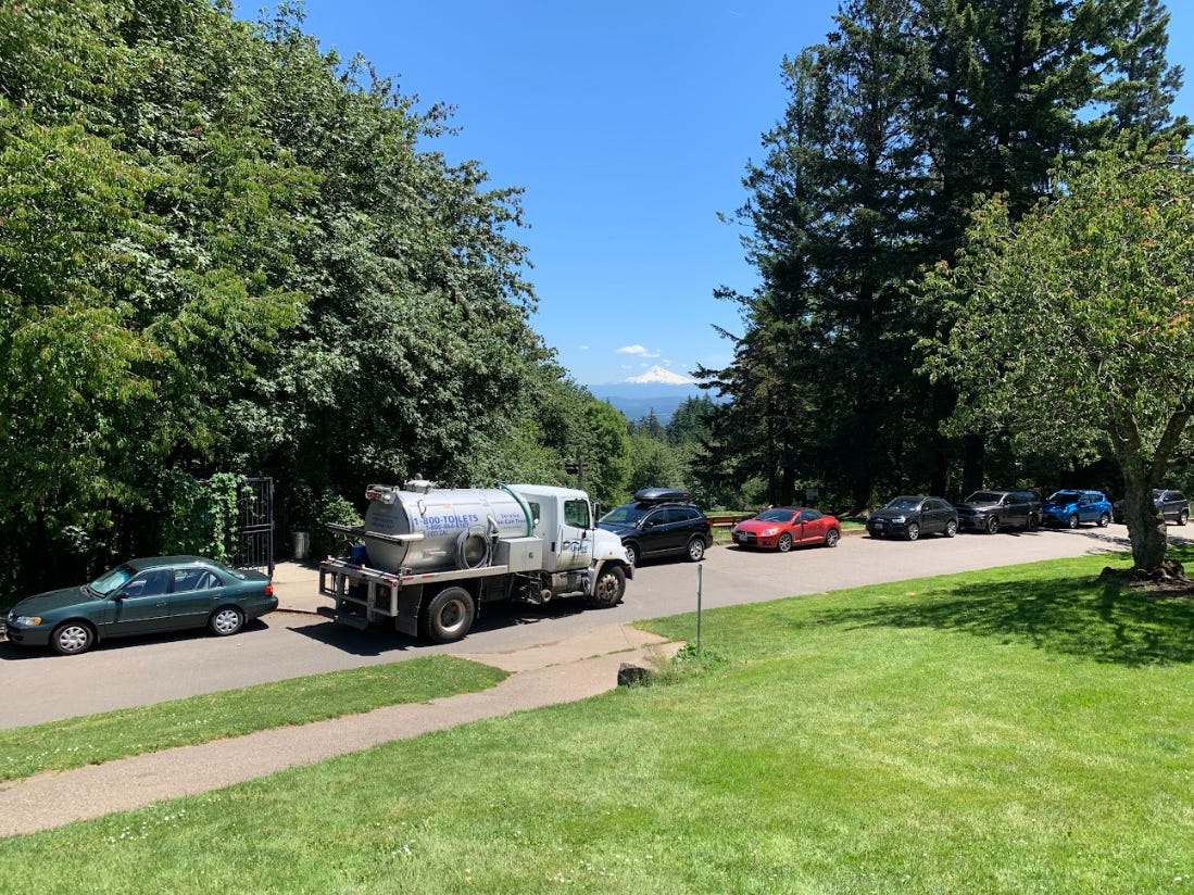
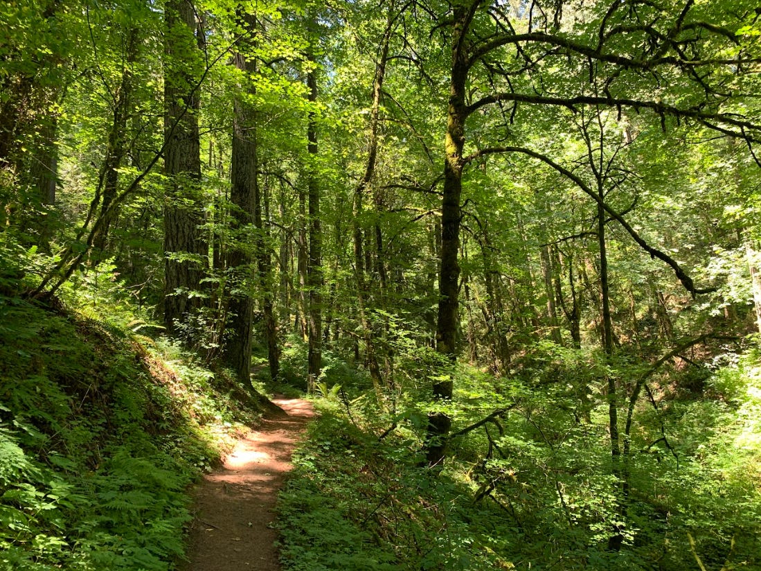
Still, if we’re talking sheer mileage and time spent moving from one place to another, the Trail portion of the 4T Trail is the heftiest chapter by far. From the very top of the tramway, I wandered into a complex of medical buildings that were part of Oregon Health & Science University (OSHU) Hospital. Here I felt even more out of place as a gear-clad day hiker, and sure enough, the trailhead for the Connor Trail—the first of several interconnected paths that the Trail portion follows—was practically hidden at the far end of a parking lot. But a colorful 4T Trail sign posted near here confirmed that I was on the right track. Minutes later, after skidding down a series of eroding switchbacks, I was in a chirping forest so rich with ferns and Douglar fir trees that it felt like a worthy backdrop for one of the Jurassic Park sequels. Occasional wooden bridges offered passage over streams descending toward the city center. Pieces of woods-adjacent houses peeked through the trees. And when I finally hauled my way out of the understory to the exposed, grassy high point of Council Crest Park, I was rewarded with a far-off view of Mount Hood’s snowy cone, and a foreground view of a septic tank truck rumbling away, its hose attached to one of the park porta potties.
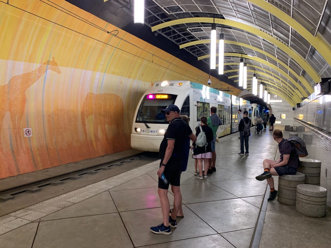
Go for a hike in a city or any residential area, and you will run into a juxtaposition like the state’s grandest mountain and the transference of raw sewage at some point. In this case, the binary forced me to say goodbye to Mount Hood quicker than I would have preferred and retreat into a nearby grove of flowers with my shirt over my nose and mouth. But underneath the shirt, I was smiling. The unlikeliness of natural and built elements colliding can be its own form of amusement or joy. And an hour later, when I approached the parking area for Oregon Zoo, I experienced the latter. A little elevator took me beneath the zoo, into an underground train station where gigantic silhouettes of giraffes and elephants were painted on the walls. It was a reflection of the wildness—the life—that existed on the surface. Not just the resident animals, but also the trees, the leafy plants, and the waterways that thrive around the Oregon Zoo.
How many hikers would find their way down here after an hour or two of sweating on the trails nestled in Portland’s hills, if Don and Eric Baack hadn’t cooked up the 4T? I’d imagine the figure would be vanishingly small, given our siloed way of thinking about trails, movement, and what qualifies as a hike. But as I mentioned earlier, millions of us are already undertaking journeys like the 4T Trail every day. Conceiving of them as trails would be like flicking a switch buried in the mossiest recesses of our brains. It’s hard to know what prompted the Baacks to make that quantum leap. But they did, and Portland is richer and more readily explorable for it. The 4T Trail signs were installed in 2009, which is really bugging me out. I mean, just think about that for a sec. 2009! Obama was our new president back then. Chelsey “Sully” Sullenberger had just saved an entire planeful of passengers by landing in the Hudson River after some geese got sucked into the jet engine. KFC was peddling the infamous Double Down sandwich.
I mention all of this to illustrate how much time has elapsed since the 4T Trail came to being, and how under-realized the idea still is. Any city and a great deal of towns could host a multi-modal trail like the 4T. And maybe the next trailblazer could be you! Hell, it wouldn’t be half as tough and time-consuming as mapping out a cross-town trail that’s built around hiking or biking exclusively. Scouting the route would mean logging some miles in the field, on foot. But it would also take a lot of riding and gliding too. Maybe you’re already doing some of that riding or gliding, as part of your daily commute. So the next time you’re getting groceries or going to the doctor, ask yourself a question.
Could this be a trail?
You might be surprised.
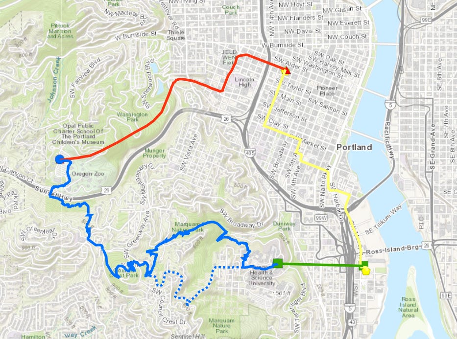
Portland’s 4T Trail
Walking distance: 7.3 miles point-to-point
Elevation gain: Roughly 800-1,000 feet
CLICK HERE for trail maps and directions
Now here’s something you probably won’t have to worry about on a multi-modal trail in a residential area. As reported by Michael Hill for the Associated Press, a bull moose is currently occupying a popular trail in the Adirondacks. (It’s the Goodman Mountain Trail.) Granted, “occupying” might be the wrong word here, since the moose is pretty much on its home turf. But a state scientist is quoted describing this bull moose’s behavior as “very unusual.” The 900-pound chunker has been sitting beside the trail and foraging around the trail. All of this reminded me of a *huge* moose that took up residence near Madison Spring Hut in the White Mountains, back when I was working there in the summer of 2011. We called her Lola. One afternoon, I emerged from the crew shower (located outdoors) and was greeted by Lola, towering above me. To this day, when getting out of the shower, I occasionally sniff the vicinity for moose musk.
While we’re on the subject of potentially dangerous situations in the outdoors, take a minute to consider why RFK Jr. is making the rounds on social media platforms this week. Not because he’s hacking away at our confidence in vaccines, and not because somebody dug up an old photo of him partying with Jeffrey Epstein, but because he apparently wears jeans while hiking. Now look; I’m hardly a purist when it comes to orthodoxies about what you should or shouldn’t wear in the backcountry. When I’m hiking through tick-infested areas, I prefer shorts to long pants because I can easily spot and remove the little fuckers that try to hitch a ride on my exposed legs. But in my decades of experience, wearing jeans on a hike—especially an extremely hot hike like the one that RFK Jr. recently took on Arizona’s Camelback Mountain—is a great way to develop a heat rash on your lower extremities. Judging from the uproar over this, I think that Tim Walz was onto something (before he was basically forced into a straitjacket by the Harris/Walz campaign management) when he recognized that the MAGA crew is not just cruel and vindictive and narcissistic. They’re really weird too.
That thing about RFK wearing jeans while on a hot hike makes my skin crawl… for many reasons!
Love the idea of creating a version of the 4T trail here in Jersey City.