

Maybe it’s the prolific penis graffiti you find on the access trails. Perhaps it’s the sheer cliffs of traprock that some of those trails scramble up and down. Or maybe it was the two teenagers (and a pug) on a motorbike that I saw riding along steep the mountain summit road the other week, dodging ribbons of ice and testing the limits of their old Yamaha motor. Whatever it is, I’m starting to become infatuated with Mount Tom.

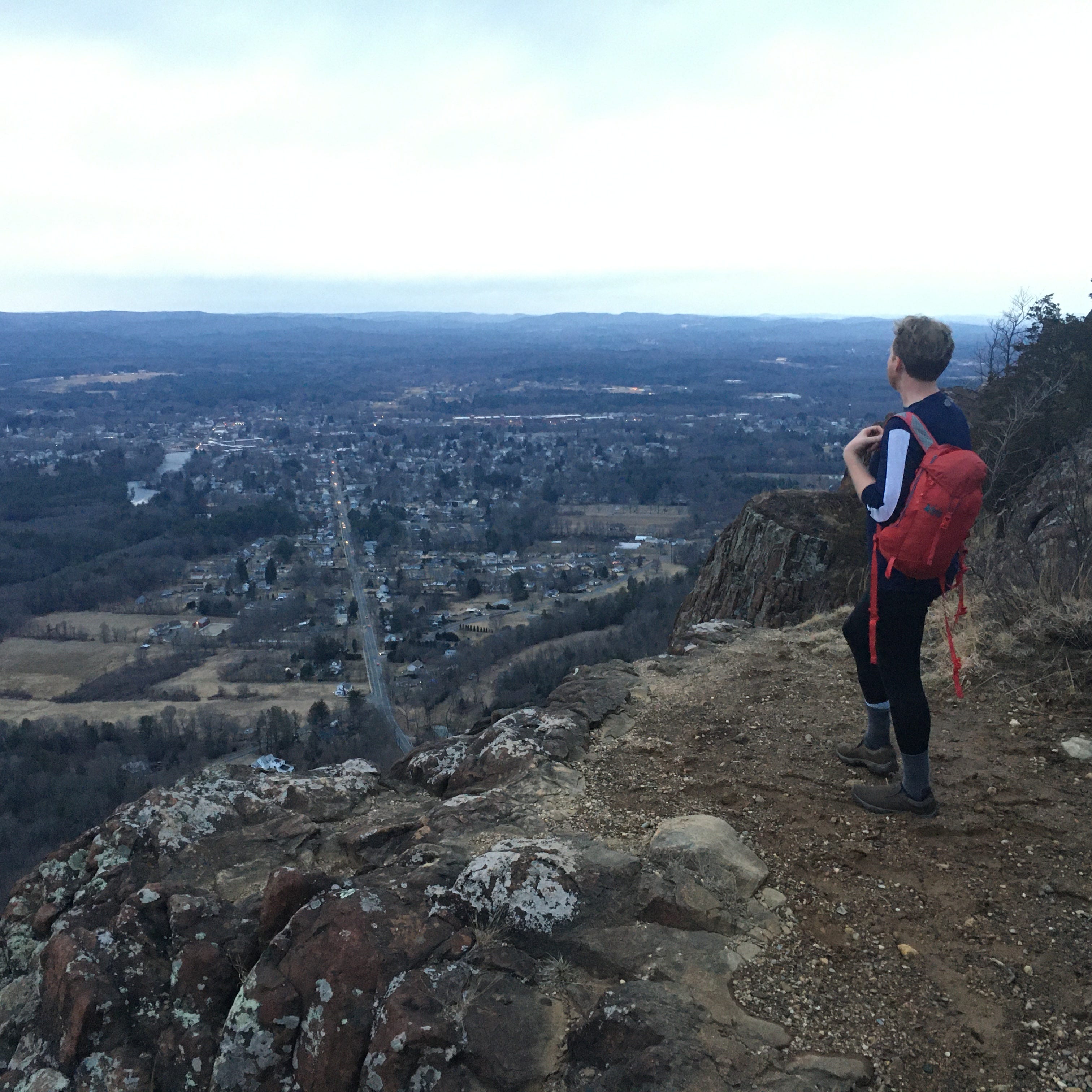
The Pioneer Valley of Massachusetts is often thought of as the on-ramp for the Berkshires, aka “real mountains” in the minds of many travelers. But if you’ve ever completed the merger between I-91 to I-90, then you’ve probably noticed this big-ass hump of a hill looming over the deciduous woodlands along the Connecticut River. This is Mount Tom, the lone alpha mountain between Holyoke and Easthampton. At 1,202 feet high, Mount Tom is not going to be the subject of a feature in Backpacker, but what this mountain may lack in stature it compensates for in ragged beauty and eccentric scenery. In other words, it’s the perfect mountain for this hiking newsletter.
Like many of its counterparts in nearby Connecticut, Mount Tom is made of traprock, a dark brown variety of basalt. I mention this because the west face of Mount Tom is a series of vertigo-inducing cliffs where you can observe traprock in its earthy glory. From the valley, it’s both intimidating and alluring, and I assume this is what inspired the land surveyor Rowland Thomas to bushwhack his way up the mountain during the 17th Century. But the decision he made after summiting was more important than the expedition itself. We’re used to hearing stories of mountains being named after noble figures like presidents or generals, but Rowland Thomas fully owned and embraced the narcissism of Columbusing an entire mountain. He just called it “Mount Tom.”

This really set the tone for things to come. The secret of Mount Tom’s charm is that in addition to being a visually intriguing mountain (with incredible and abundant views of the Pioneer Valley, I should add!) the mountain has long functioned as something of a community hub for enterprises and projects that have come and gone. In 1897, the Holyoke Street Railroad Company built an amusement park—”Mountain Park”—on the eastern slopes of Mount Tom. Today the fun house, the roller coaster, and mini-golf courses are gone, but the old paved roads that weave along Mount Tom bypass old foundations and plumbing infrastructure that emerges from the ground like some sort of alien sculpture art. Some of this stuff might have belonged to the amusement park, or possibly the lost ski resort whose abandoned chalets are nestled in the woods here.
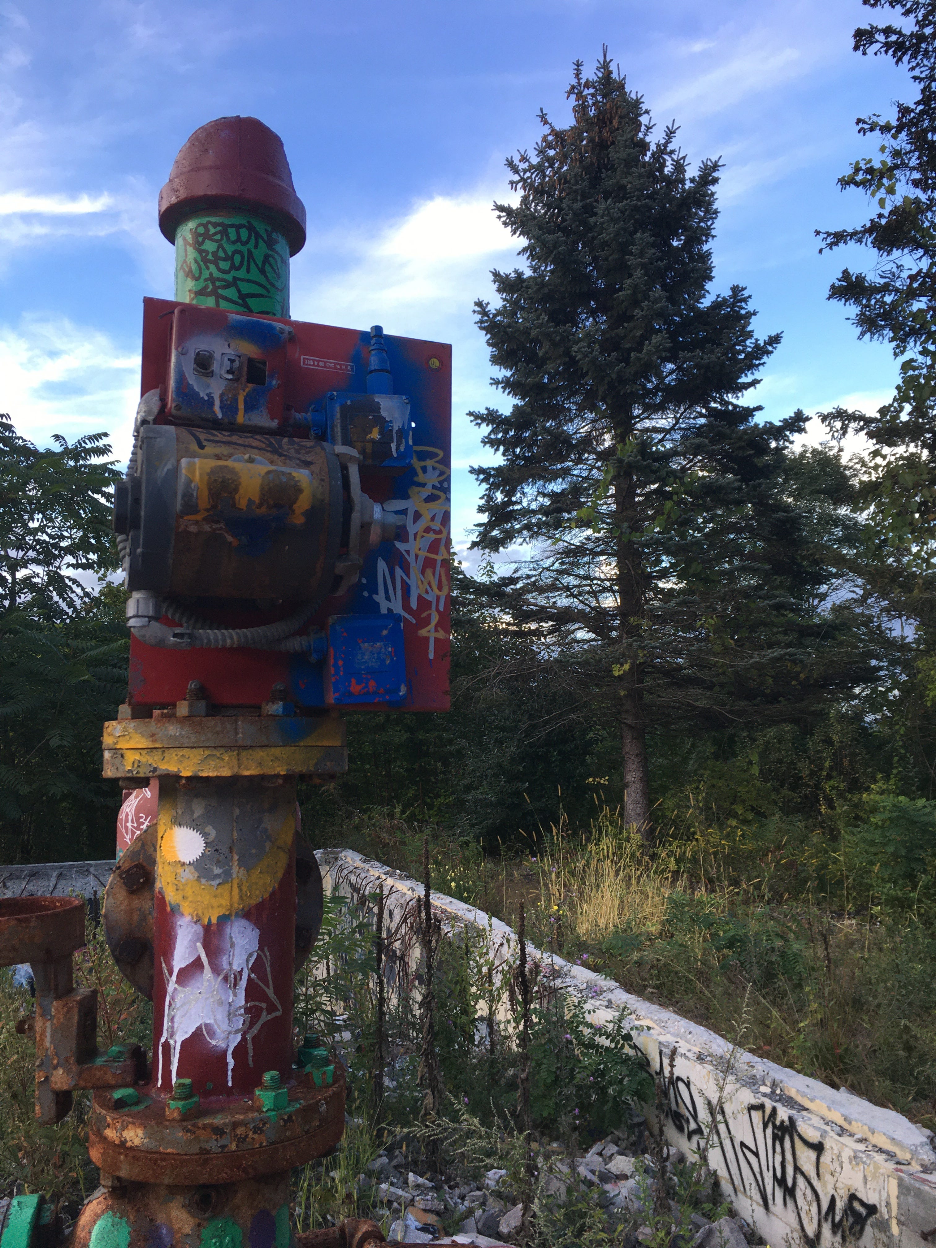
If you visit those chalets today, you’ll notice two things. They’re now festooned with a colorful heaps of fresh graffiti. And as my friend Katie pointed out the first time we hiked the east side of Mount Tom, a lot of that graffiti depicts penises. But it’s not just the old ski resort buildings that have been dicked down like this. The paved Mount Tom Ski Road (which departs from the bridge over I-91 along Mountain Park Road) is a long and winding gallery of phallic homage. Some of the cocks and nutsacks that we found last time we hiked here were adorned with the Instagram handles of the artists who painted them, so you can follow their work (adding some modernity to Mount Tom.) Naturally, we both wondered how genitalia became the dominant theme for Mount Tom’s artwork. And that’s when the teenagers on the motorbike showed up.
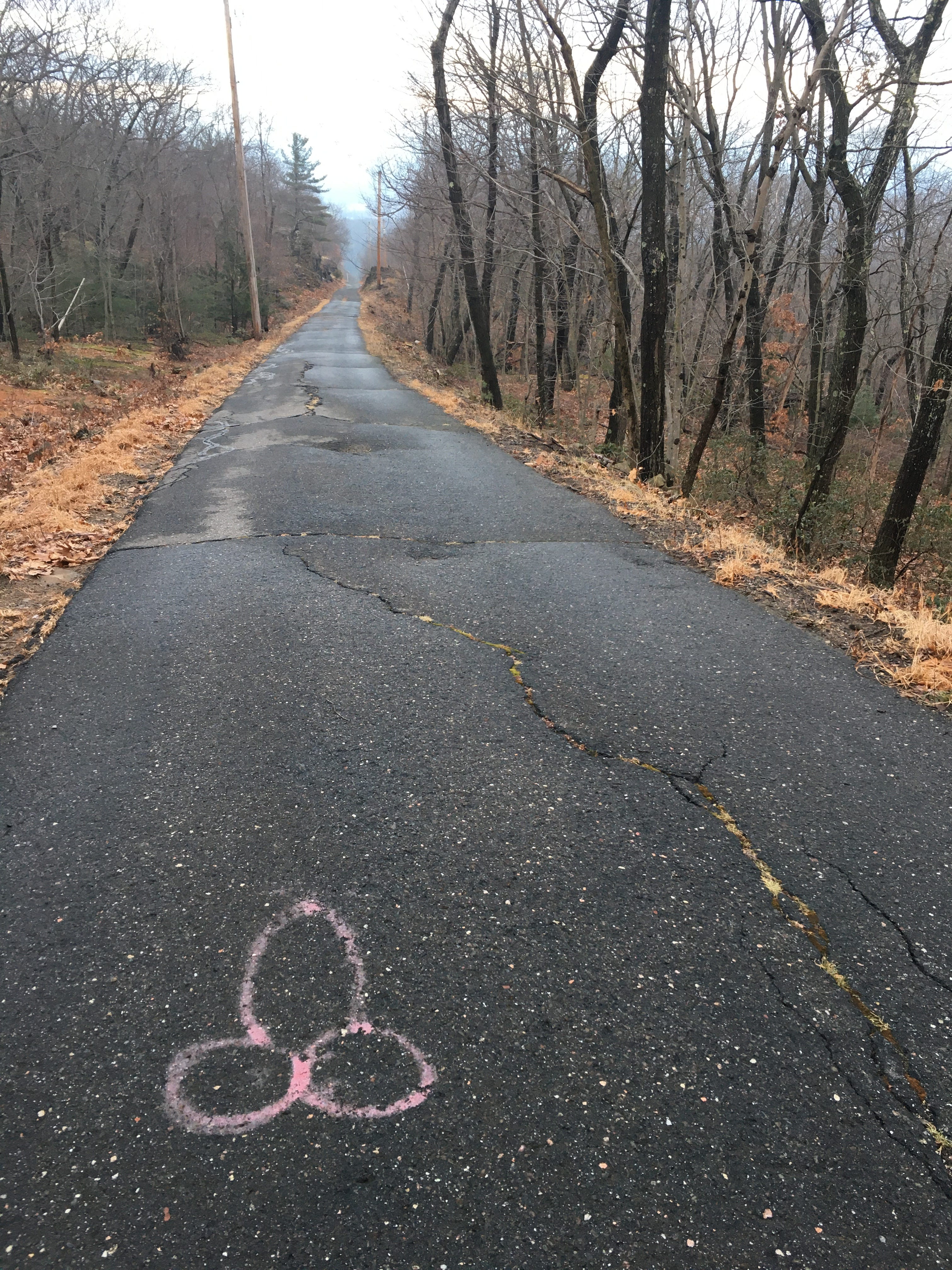


It was near sunset and we were climbing the punishingly steep access road to the summit of Mount Tom, hoping to catch the amber glow of dusk over Holyoke (the summit road diverges from the Mount Tom Ski Road.) As we huffed and carefully stepped around slivers of the road that were encased in glaze ice, the unmistakable glow of a headlight appear further up the road, heading toward us with an audible growl. We stepped aside and watched as two 15-ish looking boys on a rusty but no doubt reliable motorbike zoomed past us, ripping down the mountain road which they had evidently ascended. The kid who was steering the bike had a stoic pug in his lap. The kid on the back of bike held a portable speaker which was playing “Last Resort” by Papa Roach. We traded nods, quietly amazed that the teenagers had reached the summit on their bike, and that 15 year-olds are still listening to Papa Roach today.
We watched as the bike approached a larger puddle of ice and were terrified that the teens would try to ride right over it. But they knew what they were doing, braking slowly and maneuvering the bike around the ice. Clearly they had done this before.
It occurred to us that Mount Tom would be a five star venue for blowing off steam as a teenager, when you’re stuck in the trenches of anxiety, desire, and frustration over about what’s being asked and expected of you by adults. Whether your ideal mode of recreational activity here is smoking weed atop one of the cliffs, spray painting a door labeled “cum zone” on the side of an old ski hut, or tempting fate on the summit road with a motorbike that’s somehow still running, Mount Tom provides. When you visit the mountain, as I’ve done several times during the pandemic, you sometimes feel as though you’ve stepped onto a canvas that’s been utilized by a motley succession of characters for decades—big business, athletes, conservationists, and now, the youth.

That’s not to say that Mount Tom is just a rustling haunt for high schoolers. The west side of the lonely mountain is a codified state reservation where several trailheads are located. The most popular of these trails—the Metacomet-Monadnock Trail (aka the M&M Trail)—climbs winding stone stairs to the exposed and breezy clifftops of Mount Tom, which it follows south to the summit. It’s a moderately difficult 3.7 mile out-and-back hike that shouldn’t be attempted by anyone with a fear of heights (but it’s not nearly as scary as something like Acadia’s Precipice Trail.) The problem with hiking Mount Tom from the more naturalistic west side, however, is that the entry gates here close absurdly early at 4:00 PM—probably to keep out the miscreants who’ve made the eastern side of Mount Tom grungier. Not only does this boost the odds that you’ll find yourself nervously checking your watch as you descend Mount Tom, but sticking to the west side also means that you’re going to miss out on the oddities scattered across the more eastern side of the mountain. And the full Mount Tom experience encompasses both things: the natural and the odd.
So just for you all, I’ve taken my photos and notes from Mount Tom trips past and I’ve put together a robust loop hike route showcasing the mountain’s eccentric beauty. Not only does this 6.5 mile hike visit all of the features noted above, but it will also take you past these places:
- The B-17 Memorial. In 1946, a “Flying Fortress” bomber bringing soldiers back from Europe grazed the trees below Mount Tom’s summit and crashed into the woods. All 25 of the servicemen aboard the plane were killed in the fiery crash and today, on the side of the summit access road, you’ll find a stone memorial to the lost souls and a lonesome American flag dancing in the wind at half mast.
- The Whiting Street Reservoir. An auxiliary drinking water supply for the whole city of Holyoke. No big deal.
- Deadtop. Mount Tom is one of those elongated mountains that has sibling summits beyond the pinnacle, and this loop hike will take you over Deadtop, the second tallest point on the mountain (the stretch from here to the true summit is a clifftop hike with ample views and some exciting scrambling.)
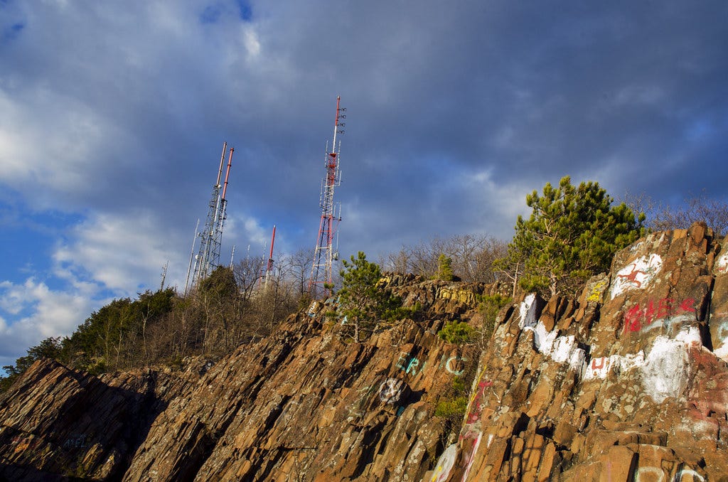
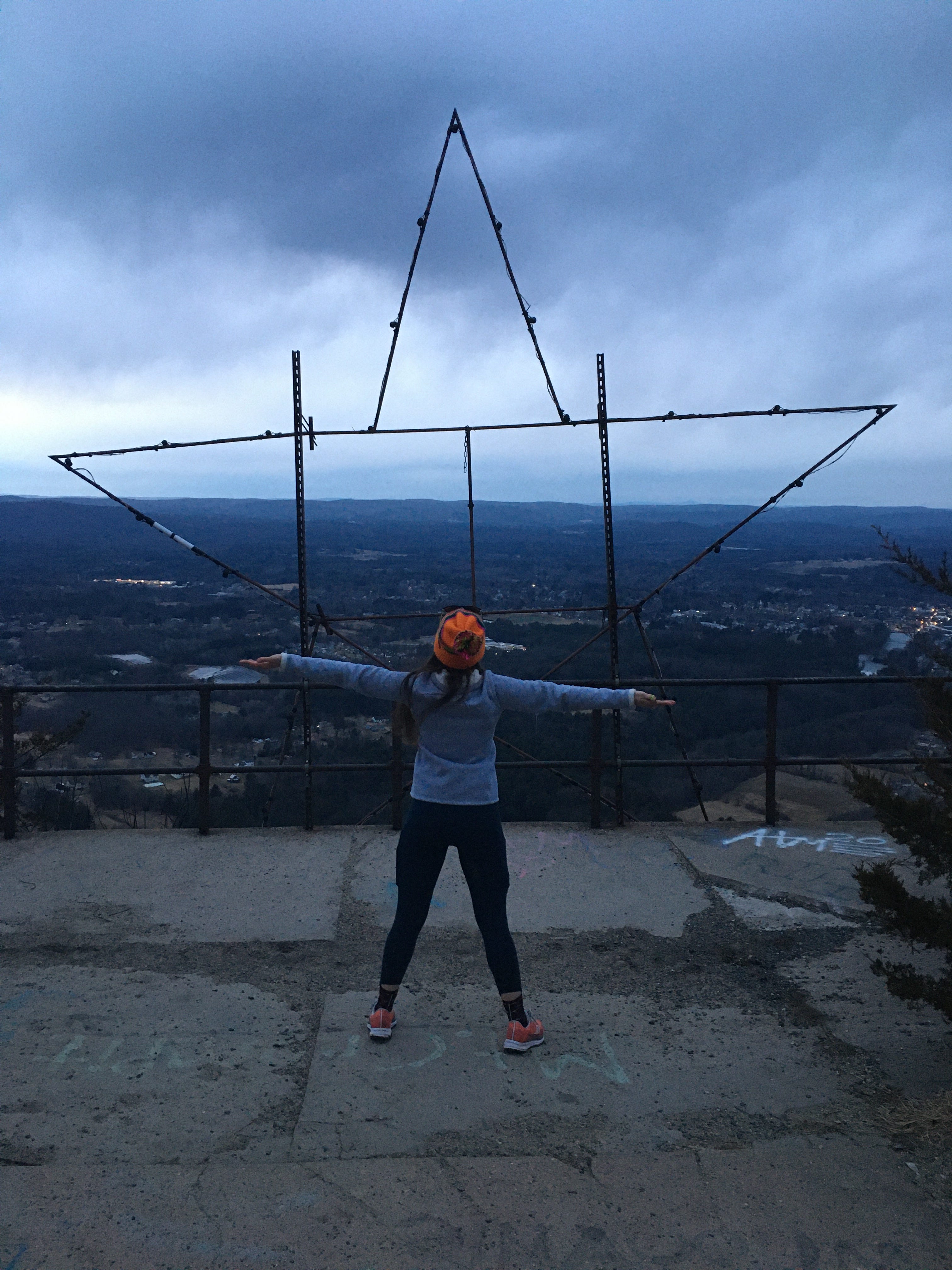
- The Mount Tom Star. The developed summit of Mount Tom is home to several radio towers, but one of its most enchanting features (and probably the most wholesome man-made creation on Mount Tom) is a large metallic star that volunteers from the Easthampton area built and attached to one of the summit lookout railings. They’ve periodically screwed LED bulbs into sockets mounted on the star and they managed to hook it up to a power source within the summit’s radio infrastructure. During the winter holidays, the Mount Tom Star is lit up after dark. It’s customary to look up from the valley and see the tiny glowing star atop Mount Tom, shining on, somehow.
Anyway, here are the deets for the loop hike…and for the more traditional and direct route to the summit of Mount Tom. (The loop is longer but also shaggier and richer.)
MOUNT TOM LOOP: MIND THE MOSS EDITION
Hike distance: 6.5 miles loop
Elevation gain: 883 feet
Park along Mountain Park Road *just before the I-91 bridge crossing*
CLICK HERE for a trail map
MOUNT TOM SUMMIT VIA THE METACOMET-MONADNOCK TRAIL (M&M TRAIL)
Hike distance: 3.7 miles out-and-back
Elevation gain: 807 feet
Park in the pullout off Christopher Clark Road
CLICK HERE for a trail map

If you’re thinking of seeing Infinite Storm, the new dramatization of Pam Bales’ 2010 hike up Mount Washington that turned into a harrowing rescue mission, my advice is to save your money (unless you have an AMC Theater subscription and need to hit your monthly movie quota to come out ahead, like I did.) The story behind the film is remarkable. Upon reaching the alpine zone amid worsening storm conditions, Bales happened upon younger man who seemed to be in a trance and was on the verge of succumbing to the winter elements. She helped him make it down the mountain via the Jewell Trail, where he got into his car and left without a word. Weeks later, he sent Bales a letter explaining that he had gone up Mount Washington unprepared because he wanted to die, and her rescuing him had renewed his will to live.
I can understand why the filmmakers wanted to bring this story to the screen, but this is one of those cases where the cinematic translation ends up giving us a distorted, melodramatic version of a quietly powerful true story. The movie was filmed in the Slovenian Alps, because I guess the real White Mountains (or even a similar-looking range in a state with better tax incentives for movie productions) didn’t appear scary enough. Bales’ courageous rescue itself has been juiced up with close brushes that involve frozen river crossings and spruce traps, which feel borrowed from other films that depict wilderness survival.
But it’s the final act, after the rescue, that really does a disservice to the source material. This is one of those endings where the main character finds a way to work the title of the film into their final lines of dialogue, just to be sure you understand what the whole thing was about. And in this case, the thematic ambitions of Infinite Storm—an attempt to find common ground between Bales and the man she rescued—feel totally unearned and superficial. For my money, the best contemporary wilderness survival movie of the last two decades is still Gus Van Sant’s Gerry.
I had to take a week-long break from hiking after my recent trip to San Francisco to report on the Crosstown Trail. Why? Because I got a monster of a blister on my little right toe after doing that hike. The sock I was wearing on Day 2 was too tight and it caused my smallest toes to bunch together and chafe from the skin-on-skin friction. SO…in the interest of sparing you the horror of pulling off your sock and finding an unsightly fluid-filled bubble on your foot, or disrobing and discovering a ghastly red rash on your backside, here’s a useful article by Backpacker on how to avoid chafing when you go hiking this spring, summer, and beyond. May your hide remain smooth.
Miles: Thank you so much for the Mt. Tom story. We used to climb Mt. Ton so ofter in the 50s and remember it dearly. It was pretty clean then and beautiful. You did a fine jobs always, with the present mountain. Gratefully, Hope