


In case you haven’t heard, Portland (our Portland) is a wonderful place for a hike. The coastal Maine citadel is to urban ramblers what Amsterdam is to cyclists; a maze of car-free paths connecting natural and built features of the cityscape, including the edible destinations for which Portland is renowned. A few years ago, when my dad and I spent a day hiking large swaths of the Portland Trails network—which boasts 70 miles of trails across the metro area—we kicked off our day with a small pile of potato batter doughnuts from the Holy Donut on the shores of Capisic Pond. Three hours later, after hiking through the buzzing marshes of the Fore River Sanctuary, we powered up for our ascent of Munjoy Hill with pulled pork sandwiches the size of bocce balls at Wilson County Barbecue. Our 13-mile trajectory was a constellation of Portland Trails, clicked together with city streets to yield a unique, delicious adventure.
But the Portland Trails network is so big that it extends well beyond the hotspots that most Portland visitors tend to seek out. As you’ll see on the map below, the trails run deep into the western suburbs of Portland. Most of the folks you’ll encounter on these trails are going to be Portland residents, using the trails as links from where they hang their hats to where they might work, shop, dine, and gallivant. But for visitors, taking a west-bound Portland Trail offers a different kind of transitional experience; an escape from Portland with a capital P. If you’ve found yourself in this city, wondering about the more snaggle-toothed underworld hidden behind the farm-to-table restaurants and tallships, the westernmost Portland Trails can be a gateway into that layer of the city ecosystem. It’s kind of like the opening montage of David Lynch’s Blue Velvet; a series of images of picturesque suburban houses. Lynch settles on one of those houses and the camera slowly burrows into the grass in the perfect front lawn, revealing a horrific extreme closeup of insects, engaged in what looks like an orgy and a feeding frenzy.

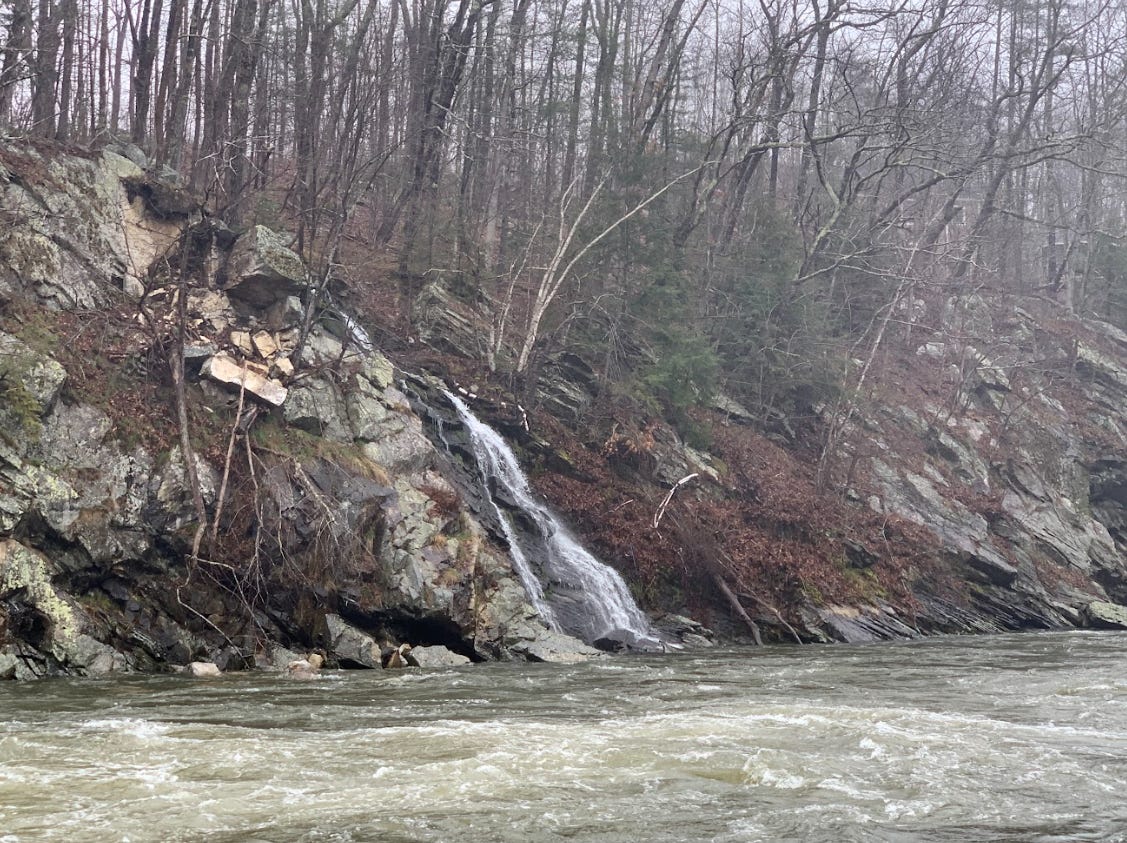
You won’t find that on the edge of Portland (unless you have a camera with a macro lens.) But what you can find is much grander and ruggedly dazzling in nature. When people talk about waterfalls in Portland, they usually focus on Jewell Falls; a modest but lovely cascade in Fore River Sanctuary. What many don’t realize is that another cascade—bigger and more thunderous—is rumbling away in relative solitude, not too far away. In fact, depending on how you look at this elusive cascade, it can be visually interpreted as a duet of watery drops. It’s called Presumpscot Falls and it looks like something which has been imported from the Maine Highlands, transplanted into a conifer-heavy suburban area. In other words, it’s a natural landmarks that’s far more representative of Maine’s wild, craggy heart than anything within downtown Portland.
Here’s how it works. The source for this crashing gusher is the Preusmpscot River; a hefty waterway that runs 25.8 miles from Sebago Lake to Casco Bay. On its journey, the river loses around 270 feet of elevation, and as the river rolls through the upper west side of Portland, it encounters a drop of around 5 feet. This yields some really impressive and cacophonous rapids, which constitute a short but explosive waterfall. But that’s just half the story. This segment of the Presumpscot River is flanked by a rockier and angular shoreline. And from the upper heights of the land, an elegant and taller horsetail waterfall spills into the torrent. It’s impossible to miss when viewed from the other side of the river, and thankfully, there’s a meandering Portland Trail which leads to the overlook from which the picture below was taken back in April.

I intentionally squirreled this story away in the “dank bank” for October, because most visitors seem to abandon the Pine Tree State as soon as peak foliage has passed. For hikers who appreciate the brooding qualities of autumnal hiking—not spooky, not melancholic, but steeped in a special, chilly mood—walking the Portland Trails in fall is a vital New England hiking experience. Especially if you’re taking the Presumpscot River Preserve Trail for an intimate view of the falls. This 3.8-mile trail is a classic riverside ramble, liberally squelchy after rainfall, but also most atmospheric at this time, when the trees themselves seem to be shaking off, after getting drenched. I chose a glowering afternoon for my visit to Presumpscot Falls, heartened by the promise that after getting muddy and perhaps a little shivery, I could peel off my damp clothes, throw them into a corner, and crack open a tallboy of black lager.
But don’t let this leave you with the idea that the Presumpscot River Preserve Trail is just a thankless and muddy slog to the main attraction. Following a river, on foot, and watching it evolve from a placid thing into a rip-roaring demon is one of the greatest ways to feel both humbled and electrified by intrigue. There’s a reason why so many stories involve journeys along the bends of waterways, from Joseph Conrad’s Heart Of Darkness and Mark Twain’s The Adventures of Huckleberry Finn to Peter Heller’s aptly-named The River. It can almost feel like a dare to follow a river, knowing that somewhere along the way, the river might surprise you with something that poses elemental danger; like an eroding bank, a flash flood, or a perilous bridge crossing (which is not really the river’s fault, but still, you get the drift.) When I set off on the Presumpscot River Preserve Trail from the trailhead on Gray Road, I was confronted by the greenish mass of the river almost immediately. I was in the presence of this titanic being. The only things left to do were walk, observe, and see what it did next.
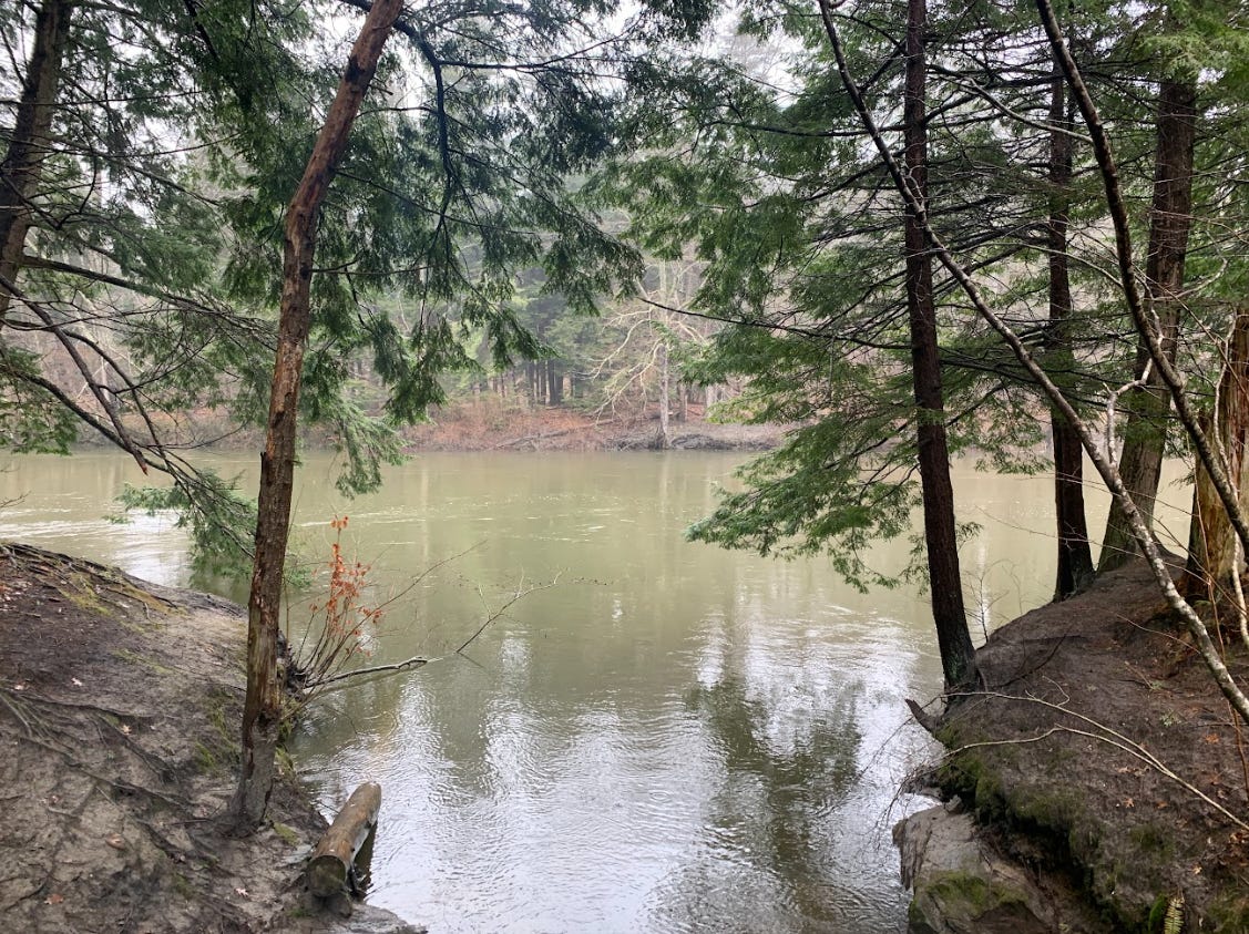
The trail hugs the wooded edge of the Presumpscot River for most of the way to the falls, occasionally dipping deeper into the shoreline woods, where you’ll often cross little wooden bridges over tributaries that spill downhill, into the king-sized river. After the first half hour of my hike, I decided to branch off of the main route and explore some of the spur paths that followed these tributaries uphill. Some of these paths lead to alternate trailheads—one of which, on Summit Street, is accessible via the Greater Portland Metro 9B bus! On one of them, after ascending some log stairs, I encountered a handmade sign from a Girl Scout Troop in nearby Falmouth (Troop #2331) imploring visitors with dogs to scoop their poop; to avoid contaminating local waters. The sign felt like something more than a PSA. It felt like one of those signs at the aquarium that asks visitors to not tap the glass on the whale tank. Not only because it’s the respectful thing to do, but because those whales are HUGE. If mistreated and agitated, a whale could shatter the glass. And if the Presumpscot River were to become contaminated, the environmental reprecussions would be felt far and wide, since the river is such a backbone to the Greater Portland metro region.

Thankfully, Portland residents and leaders are keenly aware of this. In general, Maine has a strong culture of land protection, and while that can sometimes be wielded in ways that are less-than-noble (say, to block affordable housing from being built on a vacant lot), the Portland Trails demonstrate how preserved land and developed land can be woven together almost seamlessly. For my entire jaunt on the Presumpscot River, I was surrounded by houses, on the other side of the evergreens and birches. I couldn’t see these dwellings thanks to the shape of the land and the density of the tree canopy. But they were always just a few steps away. And I found that charming.
Laying eyes on the falls themselves—the rapids and the horsetail—I felt as though I had cracked into a deeper recess of Portland. The “underworld” or understory of a city is often presumed to be a darker thing, where vice and violence thrive. But the natural foundation of a city can be an underworld of its own; overlooked, misunderstood, and in some cases, treated with apprehension. Portland has brought its own understory to the surface, with its ingenious trail network. The further west you’re willing to venture, the grittier and cooler that story becomes. Imagine yourself there this fall, or beyond.
Presumpscot Falls via the Presumpscot River Preserve Trail
Hike distance: 3.8 miles out-and-back
Elevation gain: 72 feet
CLICK HERE for an Alltrails trail map
CLICK HERE for the Portland Trails network map

As some of you have noticed, there’s often a synergy between the content and vibe of each Mind The Moss story and what I’ve been reading, watching, or listening to while writing the story—which I often allude to within each piece. So starting this week, I’m kicking off a new Moss ritual. Each subsequent newsletter will conclude with a book, movie, or song recommendation that’s spiritually connected to the featured story. As some of you may have guessed from the title of this week’s story, a certain number by The Boss was crackling in my ears as I mucked around the Portland Trails.
In broader hiking news, here’s a remarkable CNN story written by Dianne Gallagher and Michelle Watson about a man who traveled by foot through the mountains of western North Carolina to reach his parents, after the floodwaters of Hurricane Helene ripped through the area and destroyed the local roads. It’s a powerful example of a Hike Of Necessity, which might not be familiar to most Americans but is very much a form of hiking that happens throughout the world. (Traversing Panama’s treacherous Darién Gap, a requirement for thousands of migrants heading north, is one such example.)
If you’re in a position to contribute to the grassroots relief efforts that are happening in North Carolina right now, the Asheville Citizen Times has a helpful how-to primer.
Chef's kiss for Dank Bank
I love Portland Trails. I go to Jewel Falls with my cousin and our dogs a lot. My other favorite walk is Pleasant Hill Preserve in South Portland. Both have a bit of everything…meadows, marshes, piney, rocky woods. So Maine